You are here: Home > Network List > LD - Lamont-Doherty Cooperative Seismographic Network Stations List
> Station MVL Millersville University, PA > Earthquake Result Viewer
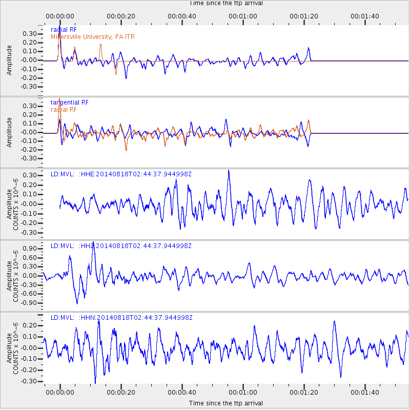
MVL Millersville University, PA - Earthquake Result Viewer
*The percent match for this event was below the threshold and hence no stack was calculated.
| Earthquake location: |
Iran-Iraq Border Region |
| Earthquake latitude/longitude: |
32.7/47.7 |
| Earthquake time(UTC): |
2014/08/18 (230) 02:32:05 GMT |
| Earthquake Depth: |
10 km |
| Earthquake Magnitude: |
6.2 MWP |
| Earthquake Catalog/Contributor: |
NEIC PDE/NEIC COMCAT |
|
| Network: |
LD Lamont-Doherty Cooperative Seismographic Network |
| Station: |
MVL Millersville University, PA |
| Lat/Lon: |
40.00 N/76.35 W |
| Elevation: |
91 m |
|
| Distance: |
91.0 deg |
| Az: |
320.447 deg |
| Baz: |
44.318 deg |
| Ray Param: |
$rayparam |
*The percent match for this event was below the threshold and hence was not used in the summary stack. |
|
| Radial Match: |
71.135086 % |
| Radial Bump: |
373 |
| Transverse Match: |
53.400795 % |
| Transverse Bump: |
400 |
| SOD ConfigId: |
769524 |
| Insert Time: |
2014-09-01 03:00:21.931 +0000 |
| GWidth: |
2.5 |
| Max Bumps: |
400 |
| Tol: |
0.001 |
|
Signal To Noise
| Channel | StoN | STA | LTA |
| LD:MVL: :HHZ:20140818T02:44:37.944998Z | 3.8096464 | 2.7214446E-7 | 7.143562E-8 |
| LD:MVL: :HHN:20140818T02:44:37.944998Z | 0.90487504 | 6.0157944E-8 | 6.648205E-8 |
| LD:MVL: :HHE:20140818T02:44:37.944998Z | 1.7051661 | 7.684653E-8 | 4.506689E-8 |
| Arrivals |
| Ps | |
| PpPs | |
| PsPs/PpSs | |


