You are here: Home > Network List > NE - New England Seismic Network Stations List
> Station EMMW Machias, ME, USA > Earthquake Result Viewer
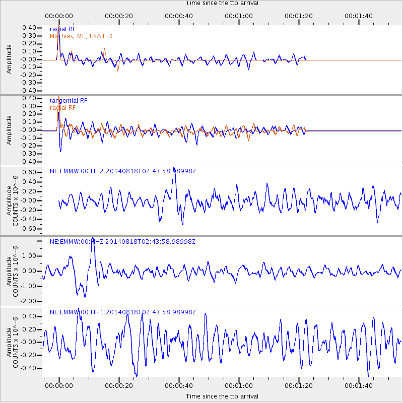
EMMW Machias, ME, USA - Earthquake Result Viewer
*The percent match for this event was below the threshold and hence no stack was calculated.
| Earthquake location: |
Iran-Iraq Border Region |
| Earthquake latitude/longitude: |
32.7/47.7 |
| Earthquake time(UTC): |
2014/08/18 (230) 02:32:05 GMT |
| Earthquake Depth: |
10 km |
| Earthquake Magnitude: |
6.2 MWP |
| Earthquake Catalog/Contributor: |
NEIC PDE/NEIC COMCAT |
|
| Network: |
NE New England Seismic Network |
| Station: |
EMMW Machias, ME, USA |
| Lat/Lon: |
44.71 N/67.46 W |
| Elevation: |
35 m |
|
| Distance: |
83.0 deg |
| Az: |
319.424 deg |
| Baz: |
50.246 deg |
| Ray Param: |
$rayparam |
*The percent match for this event was below the threshold and hence was not used in the summary stack. |
|
| Radial Match: |
73.02649 % |
| Radial Bump: |
320 |
| Transverse Match: |
63.580475 % |
| Transverse Bump: |
400 |
| SOD ConfigId: |
769524 |
| Insert Time: |
2014-09-01 03:04:44.699 +0000 |
| GWidth: |
2.5 |
| Max Bumps: |
400 |
| Tol: |
0.001 |
|
Signal To Noise
| Channel | StoN | STA | LTA |
| NE:EMMW:00:HHZ:20140818T02:43:58.98998Z | 2.787815 | 5.045475E-7 | 1.8098312E-7 |
| NE:EMMW:00:HH1:20140818T02:43:58.98998Z | 1.0114837 | 1.4278942E-7 | 1.4116827E-7 |
| NE:EMMW:00:HH2:20140818T02:43:58.98998Z | 1.4722108 | 1.8181579E-7 | 1.2349848E-7 |
| Arrivals |
| Ps | |
| PpPs | |
| PsPs/PpSs | |


