You are here: Home > Network List > NI - North-East Italy Broadband Network Stations List
> Station CIMO Cimolais > Earthquake Result Viewer
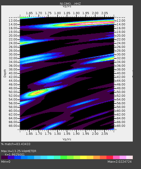
CIMO Cimolais - Earthquake Result Viewer
| Earthquake location: |
Iran-Iraq Border Region |
| Earthquake latitude/longitude: |
32.7/47.7 |
| Earthquake time(UTC): |
2014/08/18 (230) 02:32:05 GMT |
| Earthquake Depth: |
10 km |
| Earthquake Magnitude: |
6.2 MWP |
| Earthquake Catalog/Contributor: |
NEIC PDE/NEIC COMCAT |
|
| Network: |
NI North-East Italy Broadband Network |
| Station: |
CIMO Cimolais |
| Lat/Lon: |
46.31 N/12.44 E |
| Elevation: |
728 m |
|
| Distance: |
30.1 deg |
| Az: |
307.129 deg |
| Baz: |
104.216 deg |
| Ray Param: |
0.07942166 |
| Estimated Moho Depth: |
13.25 km |
| Estimated Crust Vp/Vs: |
1.98 |
| Assumed Crust Vp: |
6.35 km/s |
| Estimated Crust Vs: |
3.203 km/s |
| Estimated Crust Poisson's Ratio: |
0.33 |
|
| Radial Match: |
83.43433 % |
| Radial Bump: |
400 |
| Transverse Match: |
79.303604 % |
| Transverse Bump: |
400 |
| SOD ConfigId: |
769524 |
| Insert Time: |
2014-09-01 03:05:19.665 +0000 |
| GWidth: |
2.5 |
| Max Bumps: |
400 |
| Tol: |
0.001 |
|

Signal To Noise
| Channel | StoN | STA | LTA |
| NI:CIMO: :HHZ:20140818T02:37:44.148Z | 11.011062 | 8.595701E-7 | 7.806423E-8 |
| NI:CIMO: :HHN:20140818T02:37:44.148Z | 2.9322 | 1.7967608E-7 | 6.127688E-8 |
| NI:CIMO: :HHE:20140818T02:37:44.148Z | 8.826593 | 5.615092E-7 | 6.3615616E-8 |
| Arrivals |
| Ps | 2.2 SECOND |
| PpPs | 5.8 SECOND |
| PsPs/PpSs | 8.0 SECOND |


