You are here: Home > Network List > PE - Penn State Network Stations List
> Station PAGS PA Geological Survey > Earthquake Result Viewer
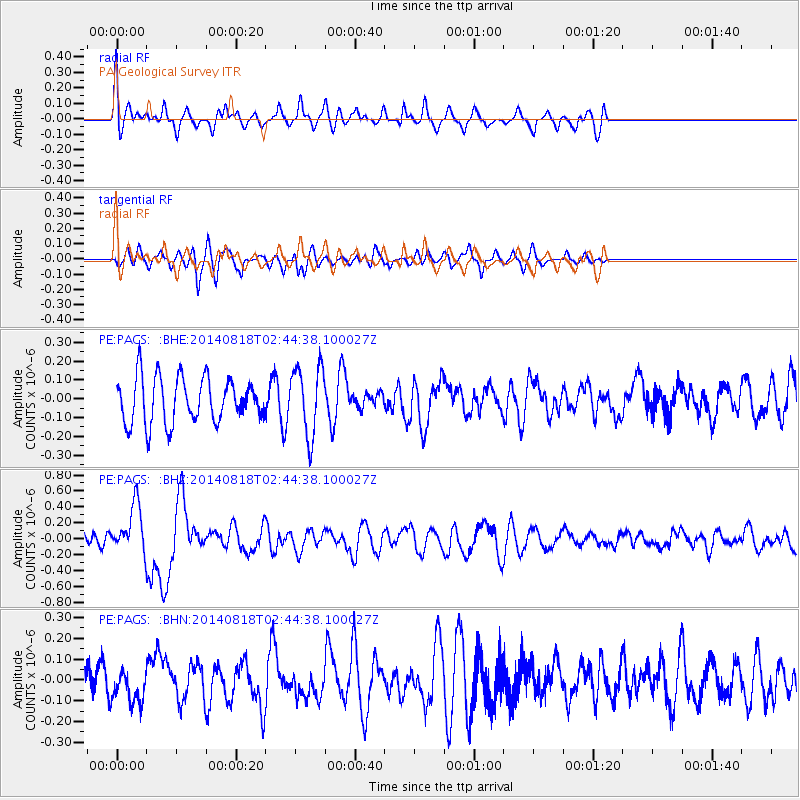
PAGS PA Geological Survey - Earthquake Result Viewer
*The percent match for this event was below the threshold and hence no stack was calculated.
| Earthquake location: |
Iran-Iraq Border Region |
| Earthquake latitude/longitude: |
32.7/47.7 |
| Earthquake time(UTC): |
2014/08/18 (230) 02:32:05 GMT |
| Earthquake Depth: |
10 km |
| Earthquake Magnitude: |
6.2 MWP |
| Earthquake Catalog/Contributor: |
NEIC PDE/NEIC COMCAT |
|
| Network: |
PE Penn State Network |
| Station: |
PAGS PA Geological Survey |
| Lat/Lon: |
40.23 N/76.72 W |
| Elevation: |
120 m |
|
| Distance: |
91.0 deg |
| Az: |
320.81 deg |
| Baz: |
44.073 deg |
| Ray Param: |
$rayparam |
*The percent match for this event was below the threshold and hence was not used in the summary stack. |
|
| Radial Match: |
66.66889 % |
| Radial Bump: |
400 |
| Transverse Match: |
35.187355 % |
| Transverse Bump: |
396 |
| SOD ConfigId: |
769524 |
| Insert Time: |
2014-09-01 03:05:42.337 +0000 |
| GWidth: |
2.5 |
| Max Bumps: |
400 |
| Tol: |
0.001 |
|
Signal To Noise
| Channel | StoN | STA | LTA |
| PE:PAGS: :BHZ:20140818T02:44:38.100027Z | 3.0261736 | 2.9660325E-7 | 9.801264E-8 |
| PE:PAGS: :BHN:20140818T02:44:38.100027Z | 0.8796224 | 7.633311E-8 | 8.67794E-8 |
| PE:PAGS: :BHE:20140818T02:44:38.100027Z | 1.5086489 | 1.8130669E-7 | 1.2017819E-7 |
| Arrivals |
| Ps | |
| PpPs | |
| PsPs/PpSs | |


