You are here: Home > Network List > TA - USArray Transportable Network (new EarthScope stations) Stations List
> Station E64A Bridgewater, ME, USA > Earthquake Result Viewer
E64A Bridgewater, ME, USA - Earthquake Result Viewer

| Earthquake location: |
Iran-Iraq Border Region |
| Earthquake latitude/longitude: |
32.7/47.7 |
| Earthquake time(UTC): |
2014/08/18 (230) 02:32:05 GMT |
| Earthquake Depth: |
10 km |
| Earthquake Magnitude: |
6.2 MWP |
| Earthquake Catalog/Contributor: |
NEIC PDE/NEIC COMCAT |
|
| Network: |
TA USArray Transportable Network (new EarthScope stations) |
| Station: |
E64A Bridgewater, ME, USA |
| Lat/Lon: |
46.42 N/67.83 W |
| Elevation: |
190 m |
|
| Distance: |
82.1 deg |
| Az: |
320.918 deg |
| Baz: |
50.176 deg |
| Ray Param: |
0.047130294 |
| Estimated Moho Depth: |
22.0 km |
| Estimated Crust Vp/Vs: |
2.10 |
| Assumed Crust Vp: |
6.419 km/s |
| Estimated Crust Vs: |
3.064 km/s |
| Estimated Crust Poisson's Ratio: |
0.35 |
|
| Radial Match: |
86.36142 % |
| Radial Bump: |
372 |
| Transverse Match: |
75.096634 % |
| Transverse Bump: |
400 |
| SOD ConfigId: |
769524 |
| Insert Time: |
2014-09-01 03:10:54.669 +0000 |
| GWidth: |
2.5 |
| Max Bumps: |
400 |
| Tol: |
0.001 |
|
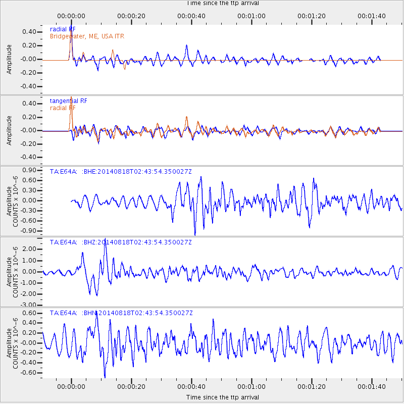
Signal To Noise
| Channel | StoN | STA | LTA |
| TA:E64A: :BHZ:20140818T02:43:54.350027Z | 5.926583 | 6.380591E-7 | 1.0766053E-7 |
| TA:E64A: :BHN:20140818T02:43:54.350027Z | 2.3357406 | 2.1949313E-7 | 9.3971536E-8 |
| TA:E64A: :BHE:20140818T02:43:54.350027Z | 1.803926 | 2.0575847E-7 | 1.1406148E-7 |
| Arrivals |
| Ps | 3.8 SECOND |
| PpPs | 10 SECOND |
| PsPs/PpSs | 14 SECOND |


