You are here: Home > Network List > TA - USArray Transportable Network (new EarthScope stations) Stations List
> Station G62A West of Eustis, ME, USA > Earthquake Result Viewer
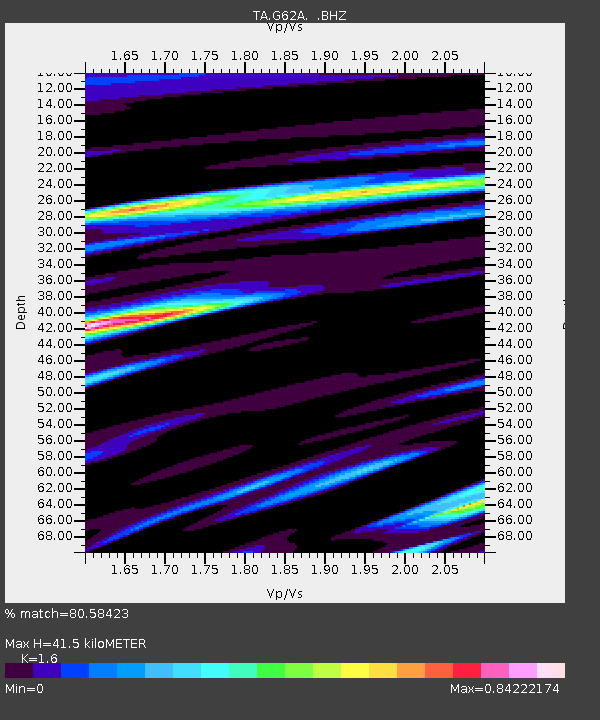
G62A West of Eustis, ME, USA - Earthquake Result Viewer
| Earthquake location: |
Iran-Iraq Border Region |
| Earthquake latitude/longitude: |
32.7/47.7 |
| Earthquake time(UTC): |
2014/08/18 (230) 02:32:05 GMT |
| Earthquake Depth: |
10 km |
| Earthquake Magnitude: |
6.2 MWP |
| Earthquake Catalog/Contributor: |
NEIC PDE/NEIC COMCAT |
|
| Network: |
TA USArray Transportable Network (new EarthScope stations) |
| Station: |
G62A West of Eustis, ME, USA |
| Lat/Lon: |
45.22 N/70.53 W |
| Elevation: |
426 m |
|
| Distance: |
84.3 deg |
| Az: |
321.246 deg |
| Baz: |
48.282 deg |
| Ray Param: |
0.04557991 |
| Estimated Moho Depth: |
41.5 km |
| Estimated Crust Vp/Vs: |
1.60 |
| Assumed Crust Vp: |
6.419 km/s |
| Estimated Crust Vs: |
4.012 km/s |
| Estimated Crust Poisson's Ratio: |
0.18 |
|
| Radial Match: |
80.58423 % |
| Radial Bump: |
400 |
| Transverse Match: |
66.65282 % |
| Transverse Bump: |
400 |
| SOD ConfigId: |
769524 |
| Insert Time: |
2014-09-01 03:12:52.156 +0000 |
| GWidth: |
2.5 |
| Max Bumps: |
400 |
| Tol: |
0.001 |
|

Signal To Noise
| Channel | StoN | STA | LTA |
| TA:G62A: :BHZ:20140818T02:44:05.74999Z | 7.5776496 | 5.9014195E-7 | 7.7879285E-8 |
| TA:G62A: :BHN:20140818T02:44:05.74999Z | 1.6381751 | 2.0177829E-7 | 1.231726E-7 |
| TA:G62A: :BHE:20140818T02:44:05.74999Z | 1.76486 | 2.446385E-7 | 1.3861637E-7 |
| Arrivals |
| Ps | 4.0 SECOND |
| PpPs | 16 SECOND |
| PsPs/PpSs | 20 SECOND |


