You are here: Home > Network List > TA - USArray Transportable Network (new EarthScope stations) Stations List
> Station R53A Hurricane, WV, USA > Earthquake Result Viewer
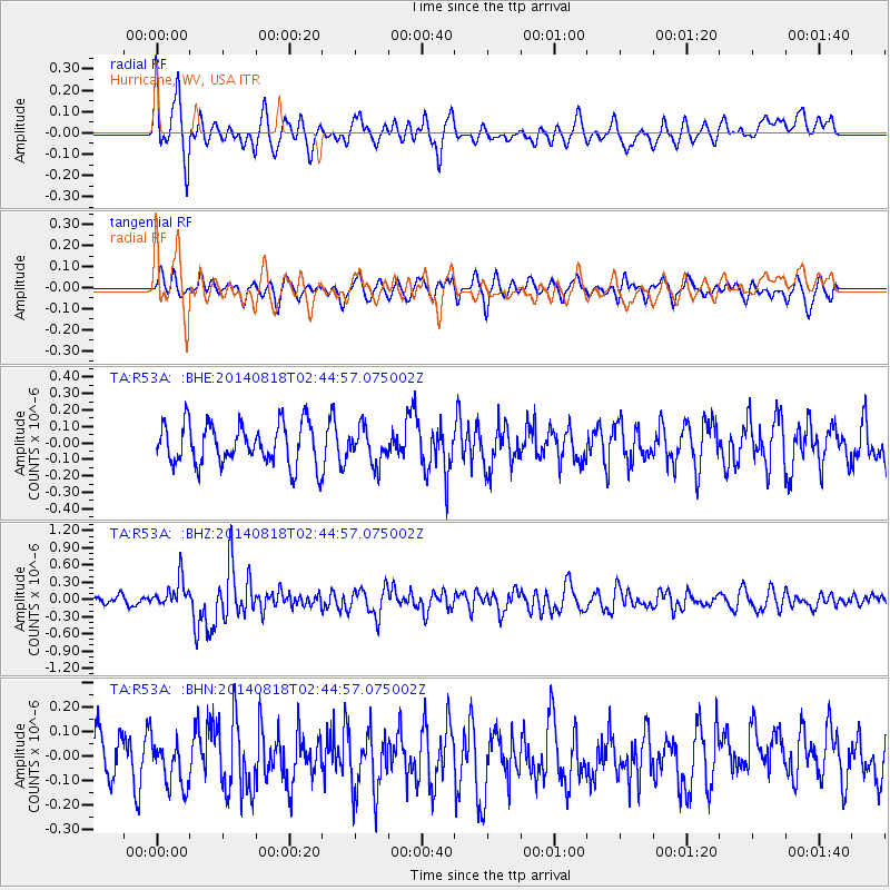
R53A Hurricane, WV, USA - Earthquake Result Viewer
*The percent match for this event was below the threshold and hence no stack was calculated.
| Earthquake location: |
Iran-Iraq Border Region |
| Earthquake latitude/longitude: |
32.7/47.7 |
| Earthquake time(UTC): |
2014/08/18 (230) 02:32:05 GMT |
| Earthquake Depth: |
10 km |
| Earthquake Magnitude: |
6.2 MWP |
| Earthquake Catalog/Contributor: |
NEIC PDE/NEIC COMCAT |
|
| Network: |
TA USArray Transportable Network (new EarthScope stations) |
| Station: |
R53A Hurricane, WV, USA |
| Lat/Lon: |
38.33 N/81.95 W |
| Elevation: |
294 m |
|
| Distance: |
95.2 deg |
| Az: |
322.535 deg |
| Baz: |
40.681 deg |
| Ray Param: |
$rayparam |
*The percent match for this event was below the threshold and hence was not used in the summary stack. |
|
| Radial Match: |
65.928856 % |
| Radial Bump: |
400 |
| Transverse Match: |
36.089054 % |
| Transverse Bump: |
399 |
| SOD ConfigId: |
769524 |
| Insert Time: |
2014-09-01 03:21:14.714 +0000 |
| GWidth: |
2.5 |
| Max Bumps: |
400 |
| Tol: |
0.001 |
|
Signal To Noise
| Channel | StoN | STA | LTA |
| TA:R53A: :BHZ:20140818T02:44:57.075002Z | 2.9033427 | 2.5192654E-7 | 8.67712E-8 |
| TA:R53A: :BHN:20140818T02:44:57.075002Z | 1.1916167 | 9.352004E-8 | 7.848165E-8 |
| TA:R53A: :BHE:20140818T02:44:57.075002Z | 0.8520663 | 1.0585162E-7 | 1.2422933E-7 |
| Arrivals |
| Ps | |
| PpPs | |
| PsPs/PpSs | |


