You are here: Home > Network List > TA - USArray Transportable Network (new EarthScope stations) Stations List
> Station T56A Rocky Mt, VA, USA > Earthquake Result Viewer
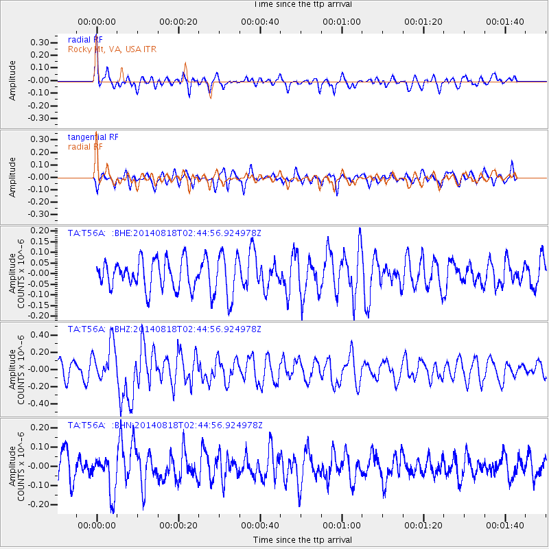
T56A Rocky Mt, VA, USA - Earthquake Result Viewer
*The percent match for this event was below the threshold and hence no stack was calculated.
| Earthquake location: |
Iran-Iraq Border Region |
| Earthquake latitude/longitude: |
32.7/47.7 |
| Earthquake time(UTC): |
2014/08/18 (230) 02:32:05 GMT |
| Earthquake Depth: |
10 km |
| Earthquake Magnitude: |
6.2 MWP |
| Earthquake Catalog/Contributor: |
NEIC PDE/NEIC COMCAT |
|
| Network: |
TA USArray Transportable Network (new EarthScope stations) |
| Station: |
T56A Rocky Mt, VA, USA |
| Lat/Lon: |
37.03 N/80.03 W |
| Elevation: |
387 m |
|
| Distance: |
95.1 deg |
| Az: |
320.524 deg |
| Baz: |
42.03 deg |
| Ray Param: |
$rayparam |
*The percent match for this event was below the threshold and hence was not used in the summary stack. |
|
| Radial Match: |
62.120308 % |
| Radial Bump: |
400 |
| Transverse Match: |
59.938168 % |
| Transverse Bump: |
400 |
| SOD ConfigId: |
769524 |
| Insert Time: |
2014-09-01 03:23:00.011 +0000 |
| GWidth: |
2.5 |
| Max Bumps: |
400 |
| Tol: |
0.001 |
|
Signal To Noise
| Channel | StoN | STA | LTA |
| TA:T56A: :BHZ:20140818T02:44:56.924978Z | 2.3791692 | 2.2616818E-7 | 9.5061836E-8 |
| TA:T56A: :BHN:20140818T02:44:56.924978Z | 1.6026367 | 9.955866E-8 | 6.212179E-8 |
| TA:T56A: :BHE:20140818T02:44:56.924978Z | 1.6549466 | 1.07208336E-7 | 6.4780544E-8 |
| Arrivals |
| Ps | |
| PpPs | |
| PsPs/PpSs | |


