You are here: Home > Network List > IU - Global Seismograph Network (GSN - IRIS/USGS) Stations List
> Station PMG Port Moresby, New Guinea > Earthquake Result Viewer
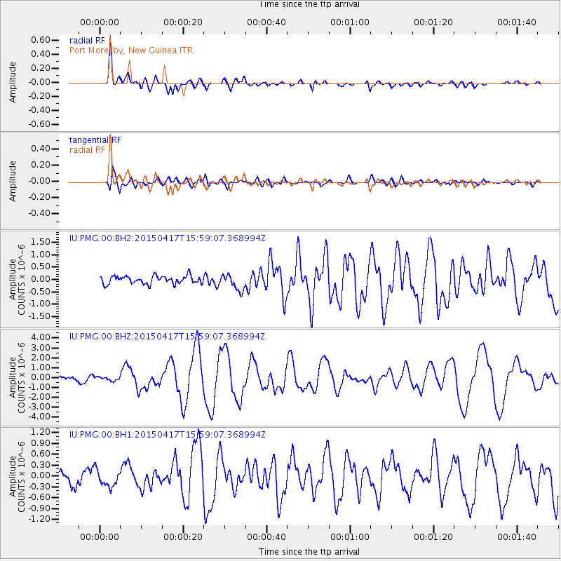
PMG Port Moresby, New Guinea - Earthquake Result Viewer
*The percent match for this event was below the threshold and hence no stack was calculated.
| Earthquake location: |
Fiji Islands Region |
| Earthquake latitude/longitude: |
-15.9/-178.6 |
| Earthquake time(UTC): |
2015/04/17 (107) 15:52:51 GMT |
| Earthquake Depth: |
10 km |
| Earthquake Magnitude: |
6.5 MWW, 6.8 MI |
| Earthquake Catalog/Contributor: |
NEIC PDE/NEIC COMCAT |
|
| Network: |
IU Global Seismograph Network (GSN - IRIS/USGS) |
| Station: |
PMG Port Moresby, New Guinea |
| Lat/Lon: |
9.40 S/147.16 E |
| Elevation: |
90 m |
|
| Distance: |
34.0 deg |
| Az: |
276.771 deg |
| Baz: |
104.46 deg |
| Ray Param: |
$rayparam |
*The percent match for this event was below the threshold and hence was not used in the summary stack. |
|
| Radial Match: |
82.88633 % |
| Radial Bump: |
400 |
| Transverse Match: |
74.95398 % |
| Transverse Bump: |
400 |
| SOD ConfigId: |
7422571 |
| Insert Time: |
2019-04-18 05:48:48.232 +0000 |
| GWidth: |
2.5 |
| Max Bumps: |
400 |
| Tol: |
0.001 |
|
Signal To Noise
| Channel | StoN | STA | LTA |
| IU:PMG:00:BHZ:20150417T15:59:07.368994Z | 0.9861756 | 1.8889459E-7 | 1.9154254E-7 |
| IU:PMG:00:BH1:20150417T15:59:07.368994Z | 1.4396337 | 2.1889858E-7 | 1.5205158E-7 |
| IU:PMG:00:BH2:20150417T15:59:07.368994Z | 1.1536348 | 1.836384E-7 | 1.5918245E-7 |
| Arrivals |
| Ps | |
| PpPs | |
| PsPs/PpSs | |


