You are here: Home > Network List > IU - Global Seismograph Network (GSN - IRIS/USGS) Stations List
> Station QSPA South Pole Remote Earth Science Observatory (Quiet Zone) > Earthquake Result Viewer
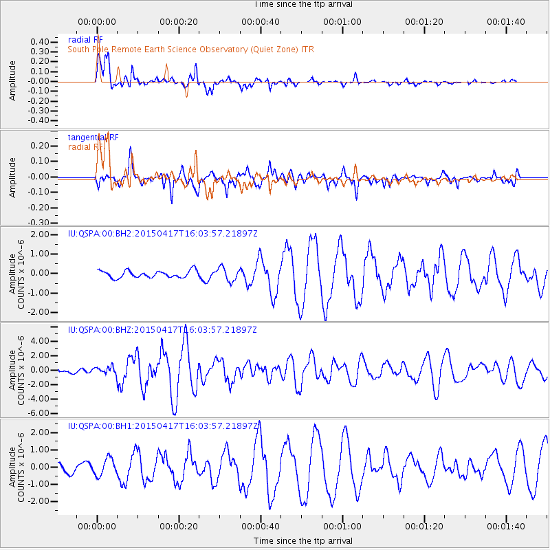
QSPA South Pole Remote Earth Science Observatory (Quiet Zone) - Earthquake Result Viewer

| Earthquake location: |
Fiji Islands Region |
| Earthquake latitude/longitude: |
-15.9/-178.6 |
| Earthquake time(UTC): |
2015/04/17 (107) 15:52:51 GMT |
| Earthquake Depth: |
10 km |
| Earthquake Magnitude: |
6.5 MWW, 6.8 MI |
| Earthquake Catalog/Contributor: |
NEIC PDE/NEIC COMCAT |
|
| Network: |
IU Global Seismograph Network (GSN - IRIS/USGS) |
| Station: |
QSPA South Pole Remote Earth Science Observatory (Quiet Zone) |
| Lat/Lon: |
89.93 S/144.44 E |
| Elevation: |
2850 m |
|
| Distance: |
74.1 deg |
| Az: |
180.045 deg |
| Baz: |
36.989 deg |
| Ray Param: |
0.052536085 |
| Estimated Moho Depth: |
19.5 km |
| Estimated Crust Vp/Vs: |
1.68 |
| Assumed Crust Vp: |
6.193 km/s |
| Estimated Crust Vs: |
3.681 km/s |
| Estimated Crust Poisson's Ratio: |
0.23 |
|
| Radial Match: |
91.25728 % |
| Radial Bump: |
358 |
| Transverse Match: |
83.348076 % |
| Transverse Bump: |
353 |
| SOD ConfigId: |
7422571 |
| Insert Time: |
2019-04-18 05:48:48.413 +0000 |
| GWidth: |
2.5 |
| Max Bumps: |
400 |
| Tol: |
0.001 |
|
Signal To Noise
| Channel | StoN | STA | LTA |
| IU:QSPA:00:BHZ:20150417T16:03:57.21897Z | 1.2843564 | 5.172831E-7 | 4.0275674E-7 |
| IU:QSPA:00:BH1:20150417T16:03:57.21897Z | 1.9983258 | 4.972721E-7 | 2.4884437E-7 |
| IU:QSPA:00:BH2:20150417T16:03:57.21897Z | 1.9030732 | 3.4662008E-7 | 1.8213701E-7 |
| Arrivals |
| Ps | 2.2 SECOND |
| PpPs | 8.2 SECOND |
| PsPs/PpSs | 10 SECOND |


