You are here: Home > Network List > IW - Intermountain West Stations List
> Station MOOW Moose Ponds, Wyoming, USA > Earthquake Result Viewer
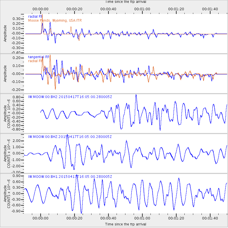
MOOW Moose Ponds, Wyoming, USA - Earthquake Result Viewer
*The percent match for this event was below the threshold and hence no stack was calculated.
| Earthquake location: |
Fiji Islands Region |
| Earthquake latitude/longitude: |
-15.9/-178.6 |
| Earthquake time(UTC): |
2015/04/17 (107) 15:52:51 GMT |
| Earthquake Depth: |
10 km |
| Earthquake Magnitude: |
6.5 MWW, 6.8 MI |
| Earthquake Catalog/Contributor: |
NEIC PDE/NEIC COMCAT |
|
| Network: |
IW Intermountain West |
| Station: |
MOOW Moose Ponds, Wyoming, USA |
| Lat/Lon: |
43.75 N/110.74 W |
| Elevation: |
2128 m |
|
| Distance: |
85.7 deg |
| Az: |
42.305 deg |
| Baz: |
243.336 deg |
| Ray Param: |
$rayparam |
*The percent match for this event was below the threshold and hence was not used in the summary stack. |
|
| Radial Match: |
79.9735 % |
| Radial Bump: |
400 |
| Transverse Match: |
78.02779 % |
| Transverse Bump: |
400 |
| SOD ConfigId: |
7422571 |
| Insert Time: |
2019-04-18 05:48:52.858 +0000 |
| GWidth: |
2.5 |
| Max Bumps: |
400 |
| Tol: |
0.001 |
|
Signal To Noise
| Channel | StoN | STA | LTA |
| IW:MOOW:00:BHZ:20150417T16:05:00.280005Z | 0.919262 | 1.5090927E-7 | 1.641635E-7 |
| IW:MOOW:00:BH1:20150417T16:05:00.280005Z | 1.5374293 | 2.958784E-7 | 1.924501E-7 |
| IW:MOOW:00:BH2:20150417T16:05:00.280005Z | 0.6702865 | 9.443317E-8 | 1.408848E-7 |
| Arrivals |
| Ps | |
| PpPs | |
| PsPs/PpSs | |


