You are here: Home > Network List > TA - USArray Transportable Network (new EarthScope stations) Stations List
> Station I61A Oroboro, Fairlee, VT, USA > Earthquake Result Viewer
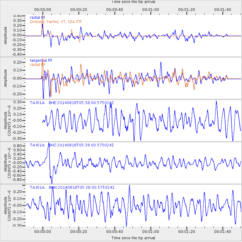
I61A Oroboro, Fairlee, VT, USA - Earthquake Result Viewer
*The percent match for this event was below the threshold and hence no stack was calculated.
| Earthquake location: |
Iran-Iraq Border Region |
| Earthquake latitude/longitude: |
32.7/47.8 |
| Earthquake time(UTC): |
2014/08/18 (230) 05:25:50 GMT |
| Earthquake Depth: |
10 km |
| Earthquake Magnitude: |
6.0 M |
| Earthquake Catalog/Contributor: |
NEIC PDE/NEIC ALERT |
|
| Network: |
TA USArray Transportable Network (new EarthScope stations) |
| Station: |
I61A Oroboro, Fairlee, VT, USA |
| Lat/Lon: |
43.93 N/72.21 W |
| Elevation: |
287 m |
|
| Distance: |
86.2 deg |
| Az: |
321.146 deg |
| Baz: |
47.096 deg |
| Ray Param: |
$rayparam |
*The percent match for this event was below the threshold and hence was not used in the summary stack. |
|
| Radial Match: |
59.08406 % |
| Radial Bump: |
400 |
| Transverse Match: |
61.27247 % |
| Transverse Bump: |
400 |
| SOD ConfigId: |
769524 |
| Insert Time: |
2014-09-01 05:59:50.260 +0000 |
| GWidth: |
2.5 |
| Max Bumps: |
400 |
| Tol: |
0.001 |
|
Signal To Noise
| Channel | StoN | STA | LTA |
| TA:I61A: :BHZ:20140818T05:38:00.575024Z | 3.4853208 | 4.5013917E-7 | 1.2915287E-7 |
| TA:I61A: :BHN:20140818T05:38:00.575024Z | 0.82530475 | 9.102251E-8 | 1.1028958E-7 |
| TA:I61A: :BHE:20140818T05:38:00.575024Z | 1.3281028 | 1.2834795E-7 | 9.664007E-8 |
| Arrivals |
| Ps | |
| PpPs | |
| PsPs/PpSs | |


