You are here: Home > Network List > US - United States National Seismic Network Stations List
> Station DGMT Dagmar, Montana, USA > Earthquake Result Viewer
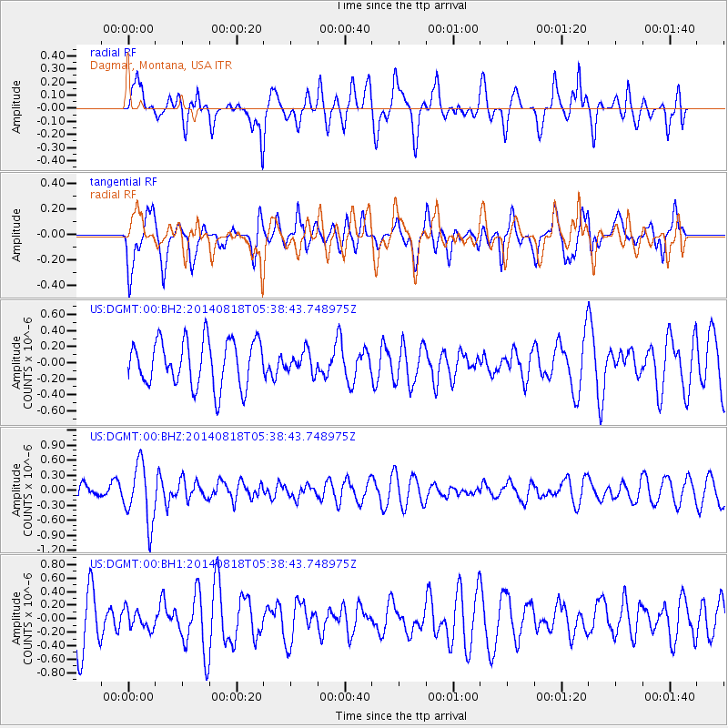
DGMT Dagmar, Montana, USA - Earthquake Result Viewer
*The percent match for this event was below the threshold and hence no stack was calculated.
| Earthquake location: |
Iran-Iraq Border Region |
| Earthquake latitude/longitude: |
32.7/47.8 |
| Earthquake time(UTC): |
2014/08/18 (230) 05:25:50 GMT |
| Earthquake Depth: |
10 km |
| Earthquake Magnitude: |
6.0 M |
| Earthquake Catalog/Contributor: |
NEIC PDE/NEIC ALERT |
|
| Network: |
US United States National Seismic Network |
| Station: |
DGMT Dagmar, Montana, USA |
| Lat/Lon: |
48.47 N/104.20 W |
| Elevation: |
0.0 m |
|
| Distance: |
95.4 deg |
| Az: |
341.677 deg |
| Baz: |
23.485 deg |
| Ray Param: |
$rayparam |
*The percent match for this event was below the threshold and hence was not used in the summary stack. |
|
| Radial Match: |
54.87262 % |
| Radial Bump: |
400 |
| Transverse Match: |
63.8015 % |
| Transverse Bump: |
400 |
| SOD ConfigId: |
769524 |
| Insert Time: |
2014-09-01 06:09:49.975 +0000 |
| GWidth: |
2.5 |
| Max Bumps: |
400 |
| Tol: |
0.001 |
|
Signal To Noise
| Channel | StoN | STA | LTA |
| US:DGMT:00:BHZ:20140818T05:38:43.748975Z | 4.462452 | 5.9302045E-7 | 1.3289116E-7 |
| US:DGMT:00:BH1:20140818T05:38:43.748975Z | 0.45198265 | 1.4106034E-7 | 3.1209237E-7 |
| US:DGMT:00:BH2:20140818T05:38:43.748975Z | 0.45003957 | 1.2949816E-7 | 2.8774838E-7 |
| Arrivals |
| Ps | |
| PpPs | |
| PsPs/PpSs | |


