You are here: Home > Network List > ZJ12 - Transantarctic Mountains Northern Network Stations List
> Station GRAW East Antarctica > Earthquake Result Viewer
GRAW East Antarctica - Earthquake Result Viewer
| Earthquake location: |
Fiji Islands Region |
| Earthquake latitude/longitude: |
-15.9/-178.6 |
| Earthquake time(UTC): |
2015/04/17 (107) 15:52:51 GMT |
| Earthquake Depth: |
10 km |
| Earthquake Magnitude: |
6.5 MWW, 6.8 MI |
| Earthquake Catalog/Contributor: |
NEIC PDE/NEIC COMCAT |
|
| Network: |
ZJ Transantarctic Mountains Northern Network |
| Station: |
GRAW East Antarctica |
| Lat/Lon: |
74.00 S/154.99 E |
| Elevation: |
2205 m |
|
| Distance: |
60.0 deg |
| Az: |
188.196 deg |
| Baz: |
29.648 deg |
| Ray Param: |
0.06184702 |
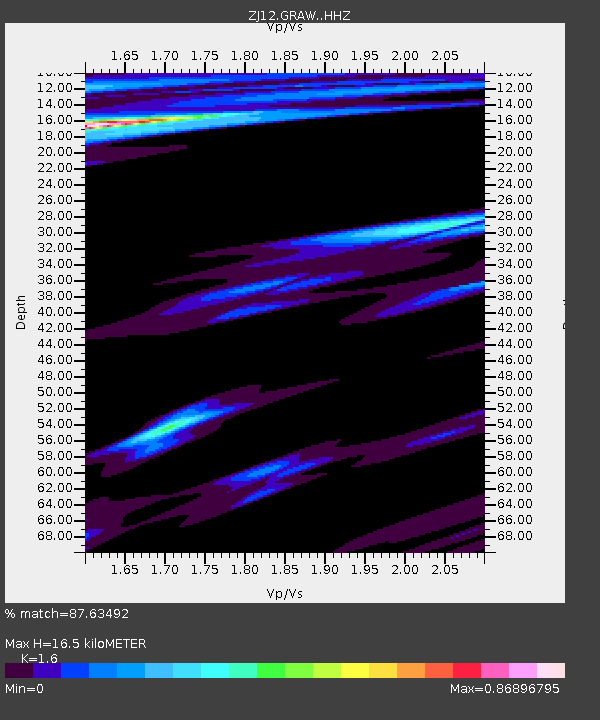
| Estimated Moho Depth: |
16.5 km |
| Estimated Crust Vp/Vs: |
1.60 |
| Assumed Crust Vp: |
6.168 km/s |
| Estimated Crust Vs: |
3.855 km/s |
| Estimated Crust Poisson's Ratio: |
0.18 |
|
| Radial Match: |
87.63492 % |
| Radial Bump: |
400 |
| Transverse Match: |
90.1354 % |
| Transverse Bump: |
400 |
| SOD ConfigId: |
7422571 |
| Insert Time: |
2019-04-18 05:53:12.319 +0000 |
| GWidth: |
2.5 |
| Max Bumps: |
400 |
| Tol: |
0.001 |
|

Signal To Noise
| Channel | StoN | STA | LTA |
| ZJ:GRAW: :HHZ:20150417T16:02:27.308997Z | 2.3233922 | 9.53378E-7 | 4.1033883E-7 |
| ZJ:GRAW: :HHN:20150417T16:02:27.308997Z | 0.904205 | 2.3761399E-7 | 2.6278772E-7 |
| ZJ:GRAW: :HHE:20150417T16:02:27.308997Z | 0.8842277 | 5.0571884E-7 | 5.719328E-7 |
| Arrivals |
| Ps | 1.7 SECOND |
| PpPs | 6.6 SECOND |
| PsPs/PpSs | 8.3 SECOND |


