You are here: Home > Network List > TA - USArray Transportable Network (new EarthScope stations) Stations List
> Station WHTX Lake Whitney, Meridian, TX, USA > Earthquake Result Viewer
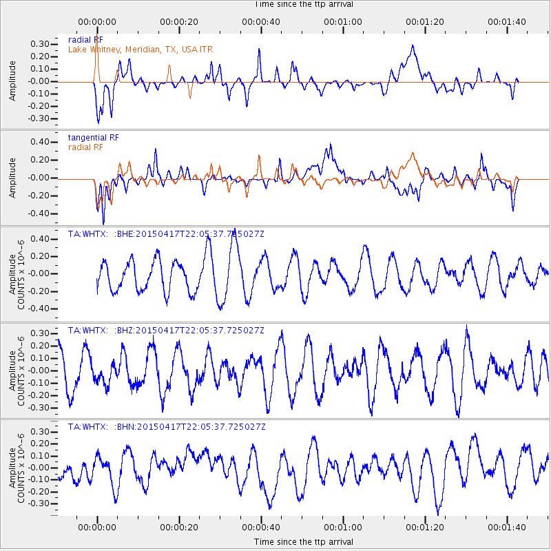
WHTX Lake Whitney, Meridian, TX, USA - Earthquake Result Viewer
*The percent match for this event was below the threshold and hence no stack was calculated.
| Earthquake location: |
South Of Fiji Islands |
| Earthquake latitude/longitude: |
-25.3/-176.2 |
| Earthquake time(UTC): |
2015/04/17 (107) 21:52:52 GMT |
| Earthquake Depth: |
21 km |
| Earthquake Magnitude: |
5.2 MW, 5.0 mb, 4.6 MS |
| Earthquake Catalog/Contributor: |
ISC/ISC |
|
| Network: |
TA USArray Transportable Network (new EarthScope stations) |
| Station: |
WHTX Lake Whitney, Meridian, TX, USA |
| Lat/Lon: |
31.99 N/97.46 W |
| Elevation: |
190 m |
|
| Distance: |
94.2 deg |
| Az: |
56.671 deg |
| Baz: |
242.873 deg |
| Ray Param: |
$rayparam |
*The percent match for this event was below the threshold and hence was not used in the summary stack. |
|
| Radial Match: |
28.636631 % |
| Radial Bump: |
400 |
| Transverse Match: |
59.098103 % |
| Transverse Bump: |
400 |
| SOD ConfigId: |
7422571 |
| Insert Time: |
2019-04-18 05:57:22.236 +0000 |
| GWidth: |
2.5 |
| Max Bumps: |
400 |
| Tol: |
0.001 |
|
Signal To Noise
| Channel | StoN | STA | LTA |
| TA:WHTX: :BHZ:20150417T22:05:37.725027Z | 0.47517994 | 7.5530636E-8 | 1.5895165E-7 |
| TA:WHTX: :BHN:20150417T22:05:37.725027Z | 2.161266 | 1.3372808E-7 | 6.187488E-8 |
| TA:WHTX: :BHE:20150417T22:05:37.725027Z | 2.0911303 | 3.4037203E-7 | 1.627694E-7 |
| Arrivals |
| Ps | |
| PpPs | |
| PsPs/PpSs | |


