You are here: Home > Network List > US - United States National Seismic Network Stations List
> Station AMTX Amarillo, Texas, USA > Earthquake Result Viewer
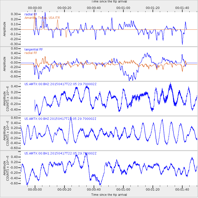
AMTX Amarillo, Texas, USA - Earthquake Result Viewer
*The percent match for this event was below the threshold and hence no stack was calculated.
| Earthquake location: |
South Of Fiji Islands |
| Earthquake latitude/longitude: |
-25.3/-176.2 |
| Earthquake time(UTC): |
2015/04/17 (107) 21:52:52 GMT |
| Earthquake Depth: |
21 km |
| Earthquake Magnitude: |
5.2 MW, 5.0 mb, 4.6 MS |
| Earthquake Catalog/Contributor: |
ISC/ISC |
|
| Network: |
US United States National Seismic Network |
| Station: |
AMTX Amarillo, Texas, USA |
| Lat/Lon: |
34.53 N/101.41 W |
| Elevation: |
1010 m |
|
| Distance: |
92.5 deg |
| Az: |
52.872 deg |
| Baz: |
240.936 deg |
| Ray Param: |
$rayparam |
*The percent match for this event was below the threshold and hence was not used in the summary stack. |
|
| Radial Match: |
53.482697 % |
| Radial Bump: |
400 |
| Transverse Match: |
37.86761 % |
| Transverse Bump: |
400 |
| SOD ConfigId: |
7422571 |
| Insert Time: |
2019-04-18 05:57:47.058 +0000 |
| GWidth: |
2.5 |
| Max Bumps: |
400 |
| Tol: |
0.001 |
|
Signal To Noise
| Channel | StoN | STA | LTA |
| US:AMTX:00:BHZ:20150417T22:05:29.700002Z | 0.62642163 | 1.5159847E-7 | 2.420071E-7 |
| US:AMTX:00:BH1:20150417T22:05:29.700002Z | 1.2725049 | 5.669455E-7 | 4.4553502E-7 |
| US:AMTX:00:BH2:20150417T22:05:29.700002Z | 1.4417413 | 2.7834085E-7 | 1.930588E-7 |
| Arrivals |
| Ps | |
| PpPs | |
| PsPs/PpSs | |


