You are here: Home > Network List > AV - Alaska Volcano Observatory Stations List
> Station MAPS Pakushin Southeast, Makushin Volcano, Alaska > Earthquake Result Viewer
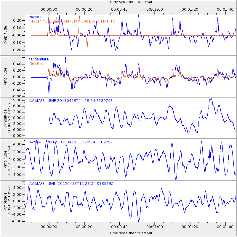
MAPS Pakushin Southeast, Makushin Volcano, Alaska - Earthquake Result Viewer
*The percent match for this event was below the threshold and hence no stack was calculated.
| Earthquake location: |
South Of Kermadec Islands |
| Earthquake latitude/longitude: |
-34.9/179.9 |
| Earthquake time(UTC): |
2015/04/18 (108) 11:16:05 GMT |
| Earthquake Depth: |
46 km |
| Earthquake Magnitude: |
5.2 MW, 5.3 mb, 4.7 MS |
| Earthquake Catalog/Contributor: |
ISC/ISC |
|
| Network: |
AV Alaska Volcano Observatory |
| Station: |
MAPS Pakushin Southeast, Makushin Volcano, Alaska |
| Lat/Lon: |
53.81 N/166.94 W |
| Elevation: |
333 m |
|
| Distance: |
89.1 deg |
| Az: |
7.757 deg |
| Baz: |
190.78 deg |
| Ray Param: |
$rayparam |
*The percent match for this event was below the threshold and hence was not used in the summary stack. |
|
| Radial Match: |
54.928986 % |
| Radial Bump: |
400 |
| Transverse Match: |
65.40042 % |
| Transverse Bump: |
400 |
| SOD ConfigId: |
7422571 |
| Insert Time: |
2019-04-18 05:59:13.342 +0000 |
| GWidth: |
2.5 |
| Max Bumps: |
400 |
| Tol: |
0.001 |
|
Signal To Noise
| Channel | StoN | STA | LTA |
| AV:MAPS: :BHZ:20150418T11:28:24.358979Z | 1.1823988 | 3.0998758E-6 | 2.621684E-6 |
| AV:MAPS: :BHN:20150418T11:28:24.358979Z | 0.62723535 | 1.6130372E-6 | 2.5716618E-6 |
| AV:MAPS: :BHE:20150418T11:28:24.358979Z | 1.2532885 | 2.6930895E-6 | 2.1488186E-6 |
| Arrivals |
| Ps | |
| PpPs | |
| PsPs/PpSs | |


