You are here: Home > Network List > TA - USArray Transportable Network (new EarthScope stations) Stations List
> Station Q56A Snyder Ridge, Maysville, WV, USA > Earthquake Result Viewer
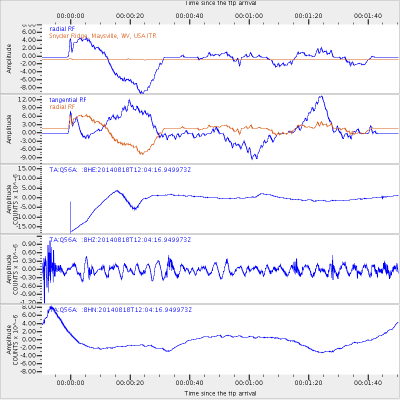
Q56A Snyder Ridge, Maysville, WV, USA - Earthquake Result Viewer
*The percent match for this event was below the threshold and hence no stack was calculated.
| Earthquake location: |
Iran-Iraq Border Region |
| Earthquake latitude/longitude: |
32.7/47.5 |
| Earthquake time(UTC): |
2014/08/18 (230) 11:51:34 GMT |
| Earthquake Depth: |
10 km |
| Earthquake Magnitude: |
5.8 MB |
| Earthquake Catalog/Contributor: |
NEIC PDE/NEIC COMCAT |
|
| Network: |
TA USArray Transportable Network (new EarthScope stations) |
| Station: |
Q56A Snyder Ridge, Maysville, WV, USA |
| Lat/Lon: |
39.04 N/79.19 W |
| Elevation: |
430 m |
|
| Distance: |
93.2 deg |
| Az: |
321.313 deg |
| Baz: |
42.588 deg |
| Ray Param: |
$rayparam |
*The percent match for this event was below the threshold and hence was not used in the summary stack. |
|
| Radial Match: |
24.651064 % |
| Radial Bump: |
400 |
| Transverse Match: |
27.243464 % |
| Transverse Bump: |
400 |
| SOD ConfigId: |
769524 |
| Insert Time: |
2014-09-01 12:20:59.019 +0000 |
| GWidth: |
2.5 |
| Max Bumps: |
400 |
| Tol: |
0.001 |
|
Signal To Noise
| Channel | StoN | STA | LTA |
| TA:Q56A: :BHZ:20140818T12:04:16.949973Z | 0.7923601 | 1.8770264E-7 | 2.3689057E-7 |
| TA:Q56A: :BHN:20140818T12:04:16.949973Z | 0.8454523 | 2.0230802E-6 | 2.392897E-6 |
| TA:Q56A: :BHE:20140818T12:04:16.949973Z | 1.0479165 | 6.568819E-6 | 6.268456E-6 |
| Arrivals |
| Ps | |
| PpPs | |
| PsPs/PpSs | |


