You are here: Home > Network List > UU - University of Utah Regional Network Stations List
> Station CCUT Cedar City, UT, USA > Earthquake Result Viewer
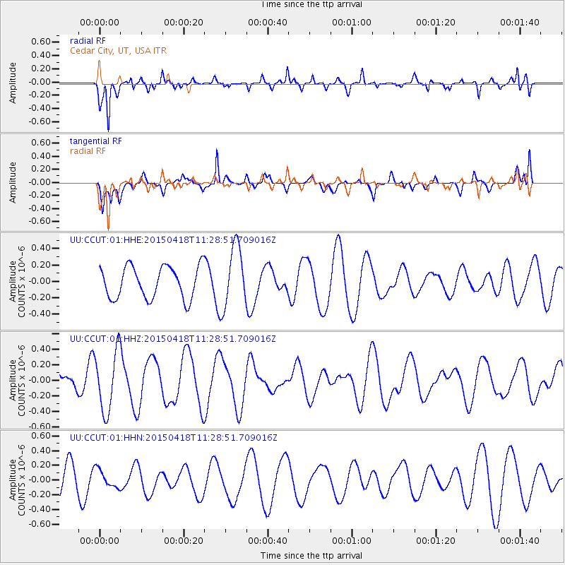
CCUT Cedar City, UT, USA - Earthquake Result Viewer
*The percent match for this event was below the threshold and hence no stack was calculated.
| Earthquake location: |
South Of Kermadec Islands |
| Earthquake latitude/longitude: |
-34.9/179.9 |
| Earthquake time(UTC): |
2015/04/18 (108) 11:16:05 GMT |
| Earthquake Depth: |
46 km |
| Earthquake Magnitude: |
5.2 MW, 5.3 mb, 4.7 MS |
| Earthquake Catalog/Contributor: |
ISC/ISC |
|
| Network: |
UU University of Utah Regional Network |
| Station: |
CCUT Cedar City, UT, USA |
| Lat/Lon: |
37.55 N/113.36 W |
| Elevation: |
2127 m |
|
| Distance: |
95.0 deg |
| Az: |
47.135 deg |
| Baz: |
229.284 deg |
| Ray Param: |
$rayparam |
*The percent match for this event was below the threshold and hence was not used in the summary stack. |
|
| Radial Match: |
59.123783 % |
| Radial Bump: |
333 |
| Transverse Match: |
62.071136 % |
| Transverse Bump: |
400 |
| SOD ConfigId: |
7422571 |
| Insert Time: |
2019-04-18 06:01:55.020 +0000 |
| GWidth: |
2.5 |
| Max Bumps: |
400 |
| Tol: |
0.001 |
|
Signal To Noise
| Channel | StoN | STA | LTA |
| UU:CCUT:01:HHZ:20150418T11:28:51.709016Z | 4.486622 | 3.8979664E-7 | 8.6879766E-8 |
| UU:CCUT:01:HHN:20150418T11:28:51.709016Z | 0.87485653 | 1.1795392E-7 | 1.3482658E-7 |
| UU:CCUT:01:HHE:20150418T11:28:51.709016Z | 1.9344506 | 3.744427E-7 | 1.9356538E-7 |
| Arrivals |
| Ps | |
| PpPs | |
| PsPs/PpSs | |


