You are here: Home > Network List > TA - USArray Transportable Network (new EarthScope stations) Stations List
> Station Z41A Richland Creek Farm, El Dorado, AR, USA > Earthquake Result Viewer
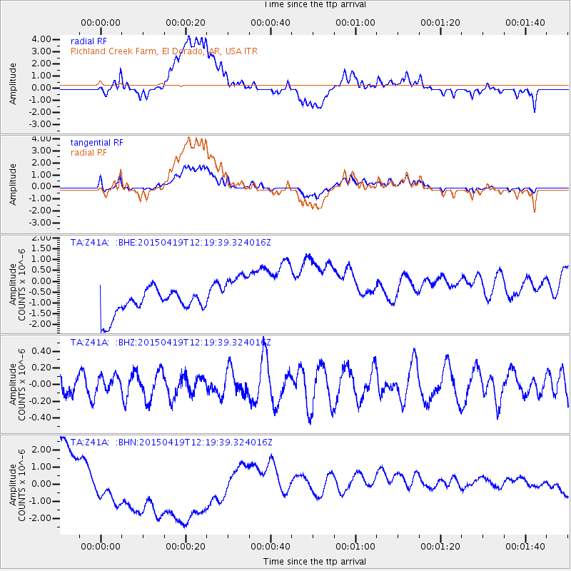
Z41A Richland Creek Farm, El Dorado, AR, USA - Earthquake Result Viewer
*The percent match for this event was below the threshold and hence no stack was calculated.
| Earthquake location: |
Southeast Of Honshu, Japan |
| Earthquake latitude/longitude: |
30.5/142.8 |
| Earthquake time(UTC): |
2015/04/19 (109) 12:06:37 GMT |
| Earthquake Depth: |
16 km |
| Earthquake Magnitude: |
5.1 MW, 4.5 MS, 5.2 mb |
| Earthquake Catalog/Contributor: |
ISC/ISC |
|
| Network: |
TA USArray Transportable Network (new EarthScope stations) |
| Station: |
Z41A Richland Creek Farm, El Dorado, AR, USA |
| Lat/Lon: |
33.26 N/92.80 W |
| Elevation: |
62 m |
|
| Distance: |
97.6 deg |
| Az: |
44.22 deg |
| Baz: |
314.1 deg |
| Ray Param: |
$rayparam |
*The percent match for this event was below the threshold and hence was not used in the summary stack. |
|
| Radial Match: |
22.448168 % |
| Radial Bump: |
400 |
| Transverse Match: |
27.514025 % |
| Transverse Bump: |
400 |
| SOD ConfigId: |
7422571 |
| Insert Time: |
2019-04-18 06:08:05.118 +0000 |
| GWidth: |
2.5 |
| Max Bumps: |
400 |
| Tol: |
0.001 |
|
Signal To Noise
| Channel | StoN | STA | LTA |
| TA:Z41A: :BHZ:20150419T12:19:39.324016Z | 0.6436984 | 9.226501E-8 | 1.4333578E-7 |
| TA:Z41A: :BHN:20150419T12:19:39.324016Z | 2.4013255 | 3.2565517E-6 | 1.3561475E-6 |
| TA:Z41A: :BHE:20150419T12:19:39.324016Z | 2.021189 | 1.1312875E-6 | 5.5971384E-7 |
| Arrivals |
| Ps | |
| PpPs | |
| PsPs/PpSs | |


