You are here: Home > Network List > NI - North-East Italy Broadband Network Stations List
> Station CIMO Cimolais > Earthquake Result Viewer
CIMO Cimolais - Earthquake Result Viewer
| Earthquake location: |
Iran-Iraq Border Region |
| Earthquake latitude/longitude: |
32.6/47.7 |
| Earthquake time(UTC): |
2014/08/18 (230) 18:08:23 GMT |
| Earthquake Depth: |
10 km |
| Earthquake Magnitude: |
5.7 MWB |
| Earthquake Catalog/Contributor: |
NEIC PDE/NEIC COMCAT |
|
| Network: |
NI North-East Italy Broadband Network |
| Station: |
CIMO Cimolais |
| Lat/Lon: |
46.31 N/12.44 E |
| Elevation: |
728 m |
|
| Distance: |
30.2 deg |
| Az: |
307.372 deg |
| Baz: |
104.479 deg |
| Ray Param: |
0.079387315 |
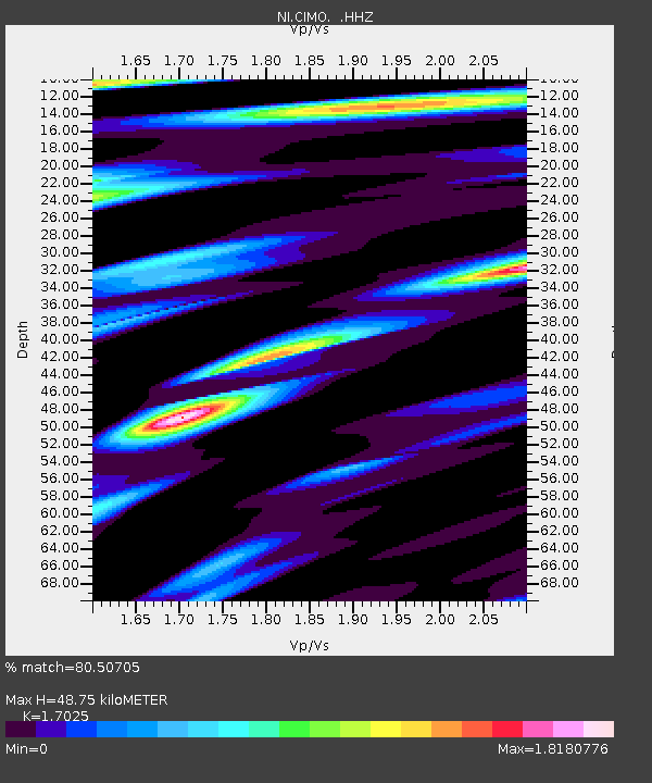
| Estimated Moho Depth: |
48.75 km |
| Estimated Crust Vp/Vs: |
1.70 |
| Assumed Crust Vp: |
6.35 km/s |
| Estimated Crust Vs: |
3.73 km/s |
| Estimated Crust Poisson's Ratio: |
0.24 |
|
| Radial Match: |
80.50705 % |
| Radial Bump: |
400 |
| Transverse Match: |
75.82411 % |
| Transverse Bump: |
400 |
| SOD ConfigId: |
769524 |
| Insert Time: |
2014-09-01 18:38:04.013 +0000 |
| GWidth: |
2.5 |
| Max Bumps: |
400 |
| Tol: |
0.001 |
|

Signal To Noise
| Channel | StoN | STA | LTA |
| NI:CIMO: :HHZ:20140818T18:14:03.858004Z | 26.55597 | 1.3590015E-6 | 5.117499E-8 |
| NI:CIMO: :HHN:20140818T18:14:03.858004Z | 6.5786085 | 3.3959887E-7 | 5.162169E-8 |
| NI:CIMO: :HHE:20140818T18:14:03.858004Z | 18.325647 | 8.5237264E-7 | 4.651255E-8 |
| Arrivals |
| Ps | 5.9 SECOND |
| PpPs | 19 SECOND |
| PsPs/PpSs | 25 SECOND |


