You are here: Home > Network List > TA - USArray Transportable Network (new EarthScope stations) Stations List
> Station I64A Boothbay, ME, USA > Earthquake Result Viewer
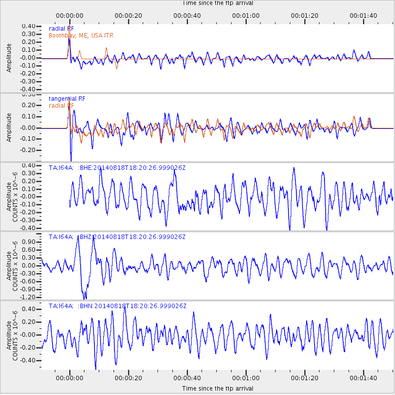
I64A Boothbay, ME, USA - Earthquake Result Viewer
*The percent match for this event was below the threshold and hence no stack was calculated.
| Earthquake location: |
Iran-Iraq Border Region |
| Earthquake latitude/longitude: |
32.6/47.7 |
| Earthquake time(UTC): |
2014/08/18 (230) 18:08:23 GMT |
| Earthquake Depth: |
10 km |
| Earthquake Magnitude: |
5.7 MWB |
| Earthquake Catalog/Contributor: |
NEIC PDE/NEIC COMCAT |
|
| Network: |
TA USArray Transportable Network (new EarthScope stations) |
| Station: |
I64A Boothbay, ME, USA |
| Lat/Lon: |
43.92 N/69.63 W |
| Elevation: |
17 m |
|
| Distance: |
84.8 deg |
| Az: |
319.866 deg |
| Baz: |
48.876 deg |
| Ray Param: |
$rayparam |
*The percent match for this event was below the threshold and hence was not used in the summary stack. |
|
| Radial Match: |
54.97838 % |
| Radial Bump: |
400 |
| Transverse Match: |
59.158638 % |
| Transverse Bump: |
400 |
| SOD ConfigId: |
769524 |
| Insert Time: |
2014-09-01 18:46:10.647 +0000 |
| GWidth: |
2.5 |
| Max Bumps: |
400 |
| Tol: |
0.001 |
|
Signal To Noise
| Channel | StoN | STA | LTA |
| TA:I64A: :BHZ:20140818T18:20:26.999026Z | 3.5240207 | 6.0393984E-7 | 1.7137806E-7 |
| TA:I64A: :BHN:20140818T18:20:26.999026Z | 1.0506712 | 1.4441486E-7 | 1.3745007E-7 |
| TA:I64A: :BHE:20140818T18:20:26.999026Z | 1.294653 | 1.7755464E-7 | 1.3714457E-7 |
| Arrivals |
| Ps | |
| PpPs | |
| PsPs/PpSs | |


