You are here: Home > Network List > TA - USArray Transportable Network (new EarthScope stations) Stations List
> Station J61A Chester, VT, USA > Earthquake Result Viewer
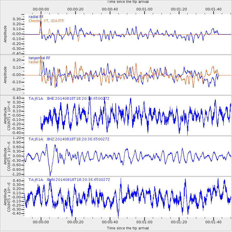
J61A Chester, VT, USA - Earthquake Result Viewer
*The percent match for this event was below the threshold and hence no stack was calculated.
| Earthquake location: |
Iran-Iraq Border Region |
| Earthquake latitude/longitude: |
32.6/47.7 |
| Earthquake time(UTC): |
2014/08/18 (230) 18:08:23 GMT |
| Earthquake Depth: |
10 km |
| Earthquake Magnitude: |
5.7 MWB |
| Earthquake Catalog/Contributor: |
NEIC PDE/NEIC COMCAT |
|
| Network: |
TA USArray Transportable Network (new EarthScope stations) |
| Station: |
J61A Chester, VT, USA |
| Lat/Lon: |
43.35 N/72.55 W |
| Elevation: |
253 m |
|
| Distance: |
86.8 deg |
| Az: |
320.864 deg |
| Baz: |
46.941 deg |
| Ray Param: |
$rayparam |
*The percent match for this event was below the threshold and hence was not used in the summary stack. |
|
| Radial Match: |
51.353542 % |
| Radial Bump: |
400 |
| Transverse Match: |
37.10336 % |
| Transverse Bump: |
400 |
| SOD ConfigId: |
769524 |
| Insert Time: |
2014-09-01 18:46:43.019 +0000 |
| GWidth: |
2.5 |
| Max Bumps: |
400 |
| Tol: |
0.001 |
|
Signal To Noise
| Channel | StoN | STA | LTA |
| TA:J61A: :BHZ:20140818T18:20:36.650027Z | 2.4901266 | 3.6952343E-7 | 1.4839544E-7 |
| TA:J61A: :BHN:20140818T18:20:36.650027Z | 1.4755384 | 1.6056062E-7 | 1.08814945E-7 |
| TA:J61A: :BHE:20140818T18:20:36.650027Z | 0.96152544 | 1.4555724E-7 | 1.5138158E-7 |
| Arrivals |
| Ps | |
| PpPs | |
| PsPs/PpSs | |


