You are here: Home > Network List > TA - USArray Transportable Network (new EarthScope stations) Stations List
> Station I23K Minto, Yukon-Koyukuk, AK, USA > Earthquake Result Viewer
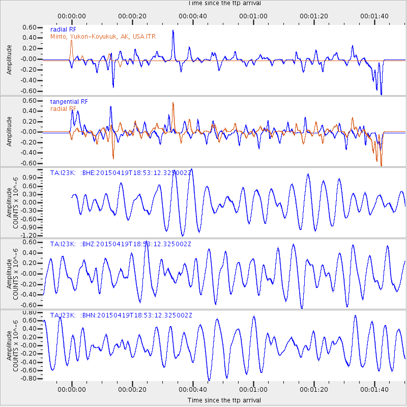
I23K Minto, Yukon-Koyukuk, AK, USA - Earthquake Result Viewer
*The percent match for this event was below the threshold and hence no stack was calculated.
| Earthquake location: |
Northern Sumatra, Indonesia |
| Earthquake latitude/longitude: |
1.9/99.0 |
| Earthquake time(UTC): |
2015/04/19 (109) 18:40:25 GMT |
| Earthquake Depth: |
124 km |
| Earthquake Magnitude: |
5.2 MW, 5.4 mb |
| Earthquake Catalog/Contributor: |
ISC/ISC |
|
| Network: |
TA USArray Transportable Network (new EarthScope stations) |
| Station: |
I23K Minto, Yukon-Koyukuk, AK, USA |
| Lat/Lon: |
65.15 N/149.36 W |
| Elevation: |
149 m |
|
| Distance: |
97.2 deg |
| Az: |
23.321 deg |
| Baz: |
290.567 deg |
| Ray Param: |
$rayparam |
*The percent match for this event was below the threshold and hence was not used in the summary stack. |
|
| Radial Match: |
33.954273 % |
| Radial Bump: |
325 |
| Transverse Match: |
39.238068 % |
| Transverse Bump: |
356 |
| SOD ConfigId: |
7422571 |
| Insert Time: |
2019-04-18 06:12:34.470 +0000 |
| GWidth: |
2.5 |
| Max Bumps: |
400 |
| Tol: |
0.001 |
|
Signal To Noise
| Channel | StoN | STA | LTA |
| TA:I23K: :BHZ:20150419T18:53:12.325002Z | 0.9108419 | 1.842845E-7 | 2.0232325E-7 |
| TA:I23K: :BHN:20150419T18:53:12.325002Z | 0.8479377 | 2.5814296E-7 | 3.0443624E-7 |
| TA:I23K: :BHE:20150419T18:53:12.325002Z | 2.5892916 | 7.622818E-7 | 2.943978E-7 |
| Arrivals |
| Ps | |
| PpPs | |
| PsPs/PpSs | |


