You are here: Home > Network List > US - United States National Seismic Network Stations List
> Station ERPA Erie, Pennsylvania, USA > Earthquake Result Viewer
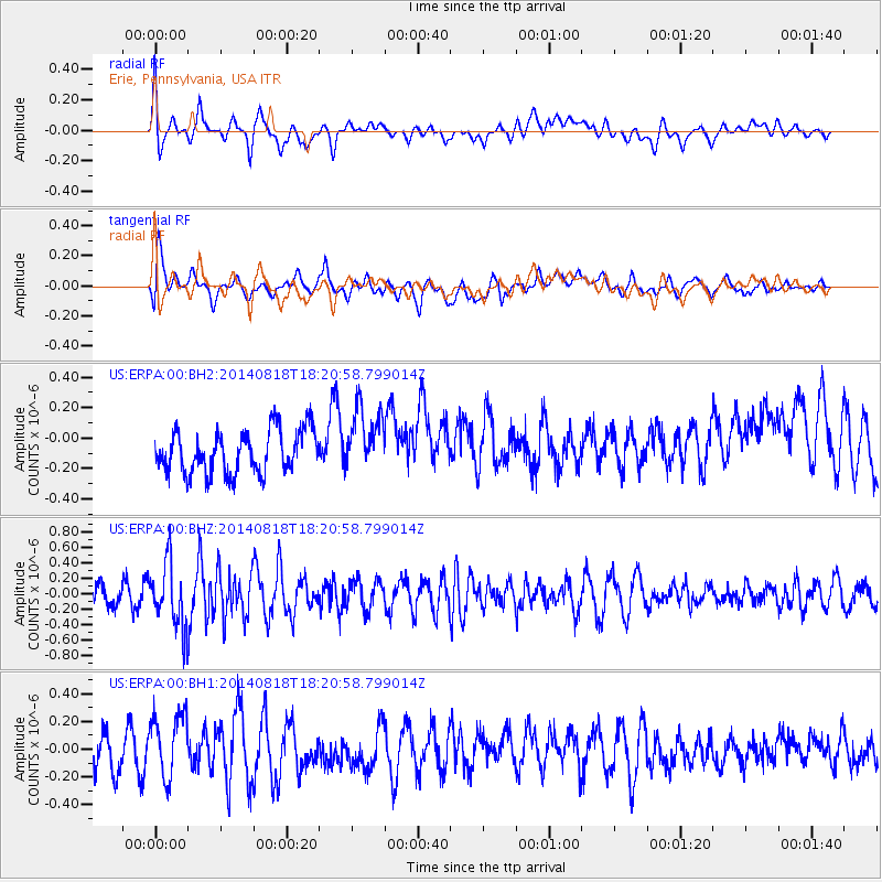
ERPA Erie, Pennsylvania, USA - Earthquake Result Viewer
*The percent match for this event was below the threshold and hence no stack was calculated.
| Earthquake location: |
Iran-Iraq Border Region |
| Earthquake latitude/longitude: |
32.6/47.7 |
| Earthquake time(UTC): |
2014/08/18 (230) 18:08:23 GMT |
| Earthquake Depth: |
10 km |
| Earthquake Magnitude: |
5.7 MWB |
| Earthquake Catalog/Contributor: |
NEIC PDE/NEIC COMCAT |
|
| Network: |
US United States National Seismic Network |
| Station: |
ERPA Erie, Pennsylvania, USA |
| Lat/Lon: |
42.12 N/79.99 W |
| Elevation: |
306 m |
|
| Distance: |
91.5 deg |
| Az: |
323.915 deg |
| Baz: |
41.955 deg |
| Ray Param: |
$rayparam |
*The percent match for this event was below the threshold and hence was not used in the summary stack. |
|
| Radial Match: |
55.22148 % |
| Radial Bump: |
400 |
| Transverse Match: |
50.12189 % |
| Transverse Bump: |
400 |
| SOD ConfigId: |
769524 |
| Insert Time: |
2014-09-01 18:55:00.067 +0000 |
| GWidth: |
2.5 |
| Max Bumps: |
400 |
| Tol: |
0.001 |
|
Signal To Noise
| Channel | StoN | STA | LTA |
| US:ERPA:00:BHZ:20140818T18:20:58.799014Z | 3.4144852 | 4.0524287E-7 | 1.18683445E-7 |
| US:ERPA:00:BH1:20140818T18:20:58.799014Z | 1.8486484 | 2.3801374E-7 | 1.2875014E-7 |
| US:ERPA:00:BH2:20140818T18:20:58.799014Z | 1.483539 | 2.1047931E-7 | 1.418765E-7 |
| Arrivals |
| Ps | |
| PpPs | |
| PsPs/PpSs | |


