You are here: Home > Network List > II - Global Seismograph Network (GSN - IRIS/IDA) Stations List
> Station ASCN Butt Crater, Ascension Island > Earthquake Result Viewer
ASCN Butt Crater, Ascension Island - Earthquake Result Viewer
| Earthquake location: |
El Salvador |
| Earthquake latitude/longitude: |
13.0/-88.7 |
| Earthquake time(UTC): |
2001/01/13 (013) 17:33:32 GMT |
| Earthquake Depth: |
60 km |
| Earthquake Magnitude: |
6.4 MB, 7.8 MS, 7.7 MW, 7.5 ME |
| Earthquake Catalog/Contributor: |
WHDF/NEIC |
|
| Network: |
II Global Seismograph Network (GSN - IRIS/IDA) |
| Station: |
ASCN Butt Crater, Ascension Island |
| Lat/Lon: |
7.93 S/14.36 W |
| Elevation: |
173 m |
|
| Distance: |
76.7 deg |
| Az: |
101.485 deg |
| Baz: |
285.399 deg |
| Ray Param: |
0.050715078 |
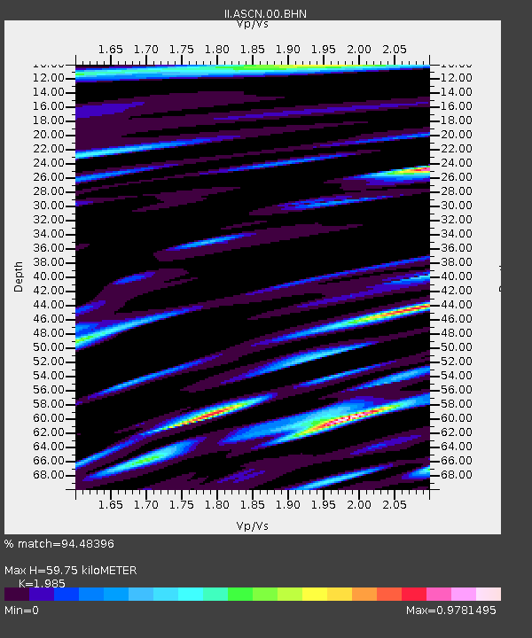
| Estimated Moho Depth: |
59.75 km |
| Estimated Crust Vp/Vs: |
1.99 |
| Assumed Crust Vp: |
4.24 km/s |
| Estimated Crust Vs: |
2.136 km/s |
| Estimated Crust Poisson's Ratio: |
0.33 |
|
| Radial Match: |
94.48396 % |
| Radial Bump: |
400 |
| Transverse Match: |
82.53128 % |
| Transverse Bump: |
400 |
| SOD ConfigId: |
3744 |
| Insert Time: |
2010-03-02 00:54:23.227 +0000 |
| GWidth: |
2.5 |
| Max Bumps: |
400 |
| Tol: |
0.001 |
|

Signal To Noise
| Channel | StoN | STA | LTA |
| II:ASCN:00:BHN:20010113T17:44:45.973994Z | 0.5322731 | 5.6339525E-7 | 1.0584703E-6 |
| II:ASCN:00:BHE:20010113T17:44:45.973994Z | 1.3308827 | 1.2850172E-6 | 9.655375E-7 |
| II:ASCN:00:BHZ:20010113T17:44:45.973994Z | 0.9044069 | 8.89469E-7 | 9.834832E-7 |
| Arrivals |
| Ps | 14 SECOND |
| PpPs | 42 SECOND |
| PsPs/PpSs | 56 SECOND |


