You are here: Home > Network List > CN - Canadian National Seismograph Network Stations List
> Station INK INUVIK, NT > Earthquake Result Viewer
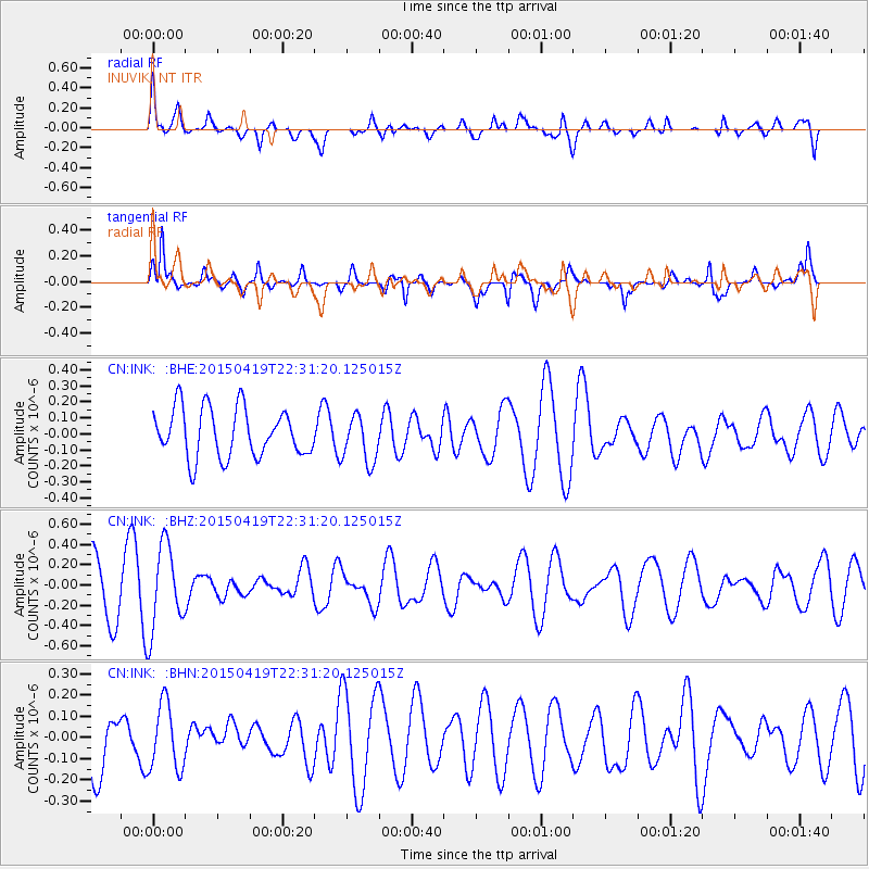
INK INUVIK, NT - Earthquake Result Viewer
*The percent match for this event was below the threshold and hence no stack was calculated.
| Earthquake location: |
Kuril Islands |
| Earthquake latitude/longitude: |
48.9/154.4 |
| Earthquake time(UTC): |
2015/04/19 (109) 22:24:35 GMT |
| Earthquake Depth: |
148 km |
| Earthquake Magnitude: |
4.0 mb, 4.1 mb |
| Earthquake Catalog/Contributor: |
ISC/ISC |
|
| Network: |
CN Canadian National Seismograph Network |
| Station: |
INK INUVIK, NT |
| Lat/Lon: |
68.31 N/133.53 W |
| Elevation: |
44 m |
|
| Distance: |
39.4 deg |
| Az: |
33.896 deg |
| Baz: |
278.208 deg |
| Ray Param: |
$rayparam |
*The percent match for this event was below the threshold and hence was not used in the summary stack. |
|
| Radial Match: |
62.587757 % |
| Radial Bump: |
400 |
| Transverse Match: |
76.850464 % |
| Transverse Bump: |
400 |
| SOD ConfigId: |
7422571 |
| Insert Time: |
2019-04-18 06:15:20.638 +0000 |
| GWidth: |
2.5 |
| Max Bumps: |
400 |
| Tol: |
0.001 |
|
Signal To Noise
| Channel | StoN | STA | LTA |
| CN:INK: :BHZ:20150419T22:31:20.125015Z | 1.694877 | 4.1882197E-7 | 2.4711053E-7 |
| CN:INK: :BHN:20150419T22:31:20.125015Z | 0.79569465 | 1.5594495E-7 | 1.9598592E-7 |
| CN:INK: :BHE:20150419T22:31:20.125015Z | 0.976182 | 1.4886871E-7 | 1.5250097E-7 |
| Arrivals |
| Ps | |
| PpPs | |
| PsPs/PpSs | |


