You are here: Home > Network List > CN - Canadian National Seismograph Network Stations List
> Station INK INUVIK, NT > Earthquake Result Viewer
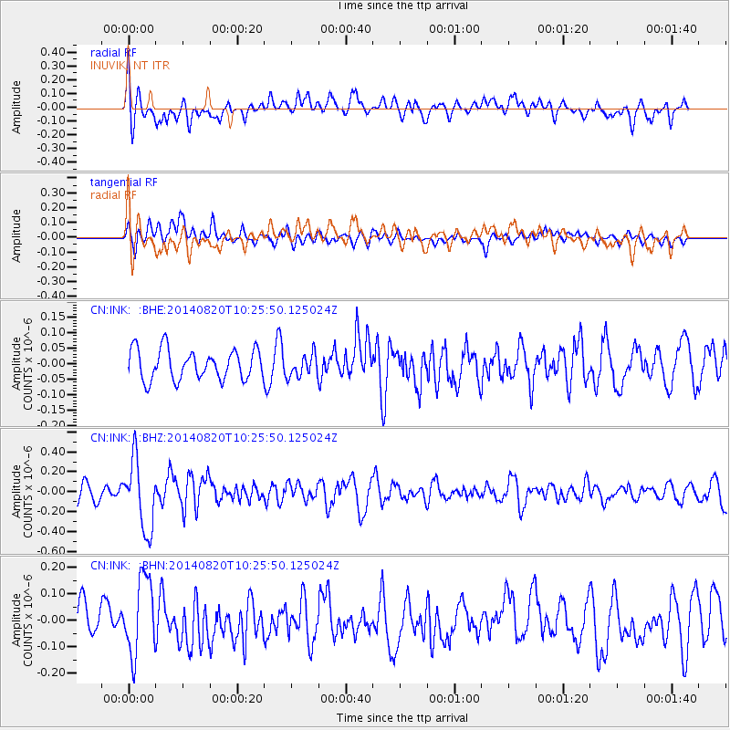
INK INUVIK, NT - Earthquake Result Viewer
*The percent match for this event was below the threshold and hence no stack was calculated.
| Earthquake location: |
Iran-Iraq Border Region |
| Earthquake latitude/longitude: |
32.6/47.8 |
| Earthquake time(UTC): |
2014/08/20 (232) 10:14:15 GMT |
| Earthquake Depth: |
10 km |
| Earthquake Magnitude: |
5.7 M |
| Earthquake Catalog/Contributor: |
NEIC PDE/NEIC ALERT |
|
| Network: |
CN Canadian National Seismograph Network |
| Station: |
INK INUVIK, NT |
| Lat/Lon: |
68.31 N/133.53 W |
| Elevation: |
44 m |
|
| Distance: |
79.4 deg |
| Az: |
0.503 deg |
| Baz: |
358.858 deg |
| Ray Param: |
$rayparam |
*The percent match for this event was below the threshold and hence was not used in the summary stack. |
|
| Radial Match: |
61.20119 % |
| Radial Bump: |
400 |
| Transverse Match: |
56.592873 % |
| Transverse Bump: |
400 |
| SOD ConfigId: |
769524 |
| Insert Time: |
2014-09-03 10:48:13.696 +0000 |
| GWidth: |
2.5 |
| Max Bumps: |
400 |
| Tol: |
0.001 |
|
Signal To Noise
| Channel | StoN | STA | LTA |
| CN:INK: :BHZ:20140820T10:25:50.125024Z | 5.4723716 | 3.5293516E-7 | 6.4494E-8 |
| CN:INK: :BHN:20140820T10:25:50.125024Z | 2.5207732 | 1.4771139E-7 | 5.8597653E-8 |
| CN:INK: :BHE:20140820T10:25:50.125024Z | 0.7563416 | 3.6796116E-8 | 4.865013E-8 |
| Arrivals |
| Ps | |
| PpPs | |
| PsPs/PpSs | |


