You are here: Home > Network List > TA - USArray Transportable Network (new EarthScope stations) Stations List
> Station D51A Lot 18 Range III Mazenod Township, QC, CAN > Earthquake Result Viewer
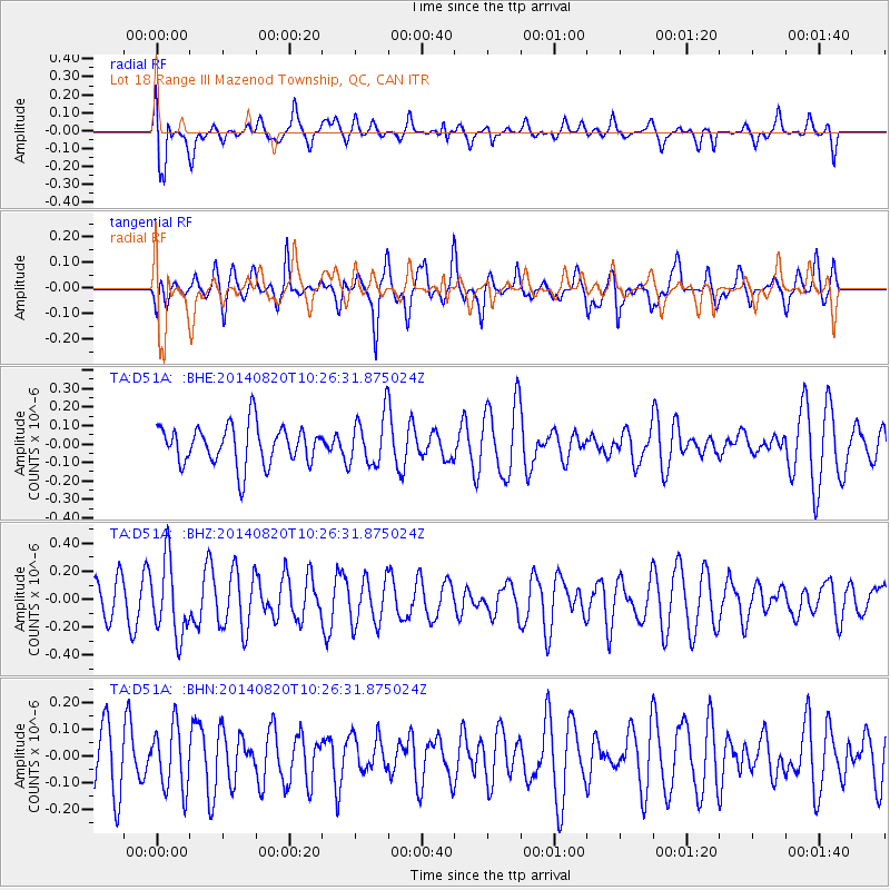
D51A Lot 18 Range III Mazenod Township, QC, CAN - Earthquake Result Viewer
*The percent match for this event was below the threshold and hence no stack was calculated.
| Earthquake location: |
Iran-Iraq Border Region |
| Earthquake latitude/longitude: |
32.6/47.8 |
| Earthquake time(UTC): |
2014/08/20 (232) 10:14:15 GMT |
| Earthquake Depth: |
10 km |
| Earthquake Magnitude: |
5.7 M |
| Earthquake Catalog/Contributor: |
NEIC PDE/NEIC ALERT |
|
| Network: |
TA USArray Transportable Network (new EarthScope stations) |
| Station: |
D51A Lot 18 Range III Mazenod Township, QC, CAN |
| Lat/Lon: |
47.09 N/79.37 W |
| Elevation: |
282 m |
|
| Distance: |
87.5 deg |
| Az: |
326.98 deg |
| Baz: |
42.289 deg |
| Ray Param: |
$rayparam |
*The percent match for this event was below the threshold and hence was not used in the summary stack. |
|
| Radial Match: |
65.59765 % |
| Radial Bump: |
400 |
| Transverse Match: |
54.38083 % |
| Transverse Bump: |
370 |
| SOD ConfigId: |
769524 |
| Insert Time: |
2014-09-03 11:01:18.591 +0000 |
| GWidth: |
2.5 |
| Max Bumps: |
400 |
| Tol: |
0.001 |
|
Signal To Noise
| Channel | StoN | STA | LTA |
| TA:D51A: :BHZ:20140820T10:26:31.875024Z | 2.139487 | 2.6691842E-7 | 1.2475813E-7 |
| TA:D51A: :BHN:20140820T10:26:31.875024Z | 1.0304981 | 1.1908224E-7 | 1.1555793E-7 |
| TA:D51A: :BHE:20140820T10:26:31.875024Z | 1.2628002 | 1.3379606E-7 | 1.05951884E-7 |
| Arrivals |
| Ps | |
| PpPs | |
| PsPs/PpSs | |


