You are here: Home > Network List > TA - USArray Transportable Network (new EarthScope stations) Stations List
> Station G63A Kingsbury, ME, USA > Earthquake Result Viewer
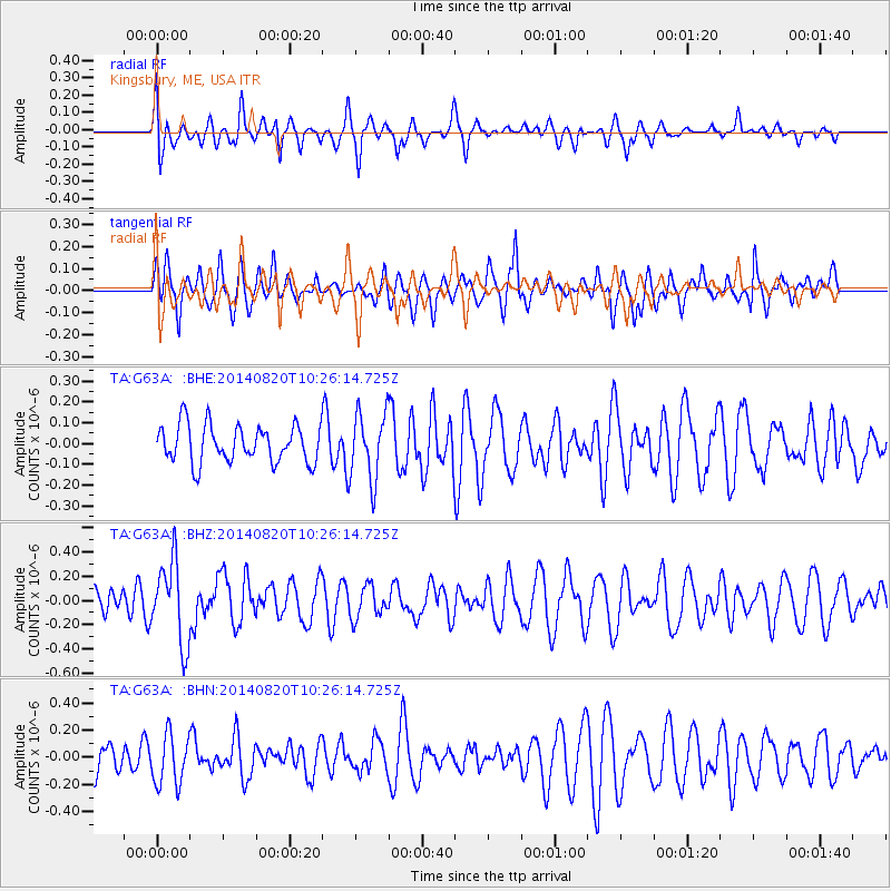
G63A Kingsbury, ME, USA - Earthquake Result Viewer
*The percent match for this event was below the threshold and hence no stack was calculated.
| Earthquake location: |
Iran-Iraq Border Region |
| Earthquake latitude/longitude: |
32.6/47.8 |
| Earthquake time(UTC): |
2014/08/20 (232) 10:14:15 GMT |
| Earthquake Depth: |
10 km |
| Earthquake Magnitude: |
5.7 M |
| Earthquake Catalog/Contributor: |
NEIC PDE/NEIC ALERT |
|
| Network: |
TA USArray Transportable Network (new EarthScope stations) |
| Station: |
G63A Kingsbury, ME, USA |
| Lat/Lon: |
45.11 N/69.62 W |
| Elevation: |
363 m |
|
| Distance: |
84.0 deg |
| Az: |
320.808 deg |
| Baz: |
48.849 deg |
| Ray Param: |
$rayparam |
*The percent match for this event was below the threshold and hence was not used in the summary stack. |
|
| Radial Match: |
64.45299 % |
| Radial Bump: |
379 |
| Transverse Match: |
53.260727 % |
| Transverse Bump: |
399 |
| SOD ConfigId: |
769524 |
| Insert Time: |
2014-09-03 11:03:55.656 +0000 |
| GWidth: |
2.5 |
| Max Bumps: |
400 |
| Tol: |
0.001 |
|
Signal To Noise
| Channel | StoN | STA | LTA |
| TA:G63A: :BHZ:20140820T10:26:14.725Z | 1.8601794 | 3.386467E-7 | 1.8205056E-7 |
| TA:G63A: :BHN:20140820T10:26:14.725Z | 1.1616008 | 1.8575953E-7 | 1.5991684E-7 |
| TA:G63A: :BHE:20140820T10:26:14.725Z | 1.8093557 | 1.6164093E-7 | 8.933618E-8 |
| Arrivals |
| Ps | |
| PpPs | |
| PsPs/PpSs | |


