You are here: Home > Network List > TA - USArray Transportable Network (new EarthScope stations) Stations List
> Station N60A Cedar Hill Farm, Mount Bethel, PA, USA > Earthquake Result Viewer
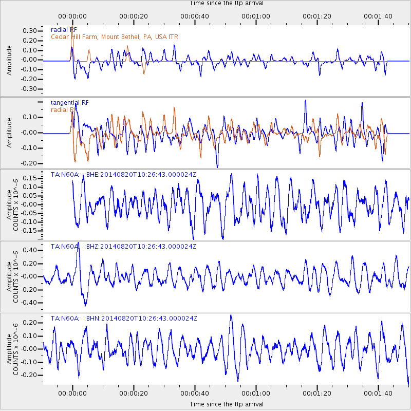
N60A Cedar Hill Farm, Mount Bethel, PA, USA - Earthquake Result Viewer
*The percent match for this event was below the threshold and hence no stack was calculated.
| Earthquake location: |
Iran-Iraq Border Region |
| Earthquake latitude/longitude: |
32.6/47.8 |
| Earthquake time(UTC): |
2014/08/20 (232) 10:14:15 GMT |
| Earthquake Depth: |
10 km |
| Earthquake Magnitude: |
5.7 M |
| Earthquake Catalog/Contributor: |
NEIC PDE/NEIC ALERT |
|
| Network: |
TA USArray Transportable Network (new EarthScope stations) |
| Station: |
N60A Cedar Hill Farm, Mount Bethel, PA, USA |
| Lat/Lon: |
40.87 N/75.10 W |
| Elevation: |
189 m |
|
| Distance: |
89.9 deg |
| Az: |
320.454 deg |
| Baz: |
45.101 deg |
| Ray Param: |
$rayparam |
*The percent match for this event was below the threshold and hence was not used in the summary stack. |
|
| Radial Match: |
63.78169 % |
| Radial Bump: |
400 |
| Transverse Match: |
54.767467 % |
| Transverse Bump: |
400 |
| SOD ConfigId: |
769524 |
| Insert Time: |
2014-09-03 11:08:20.675 +0000 |
| GWidth: |
2.5 |
| Max Bumps: |
400 |
| Tol: |
0.001 |
|
Signal To Noise
| Channel | StoN | STA | LTA |
| TA:N60A: :BHZ:20140820T10:26:43.000024Z | 3.1712606 | 2.807532E-7 | 8.853048E-8 |
| TA:N60A: :BHN:20140820T10:26:43.000024Z | 1.1397562 | 1.0117751E-7 | 8.877119E-8 |
| TA:N60A: :BHE:20140820T10:26:43.000024Z | 1.0834076 | 6.6773815E-8 | 6.1633145E-8 |
| Arrivals |
| Ps | |
| PpPs | |
| PsPs/PpSs | |


