You are here: Home > Network List > US - United States National Seismic Network Stations List
> Station DGMT Dagmar, Montana, USA > Earthquake Result Viewer
DGMT Dagmar, Montana, USA - Earthquake Result Viewer
*The percent match for this event was below the threshold and hence no stack was calculated.
| Earthquake location: |
Iran-Iraq Border Region |
| Earthquake latitude/longitude: |
32.6/47.8 |
| Earthquake time(UTC): |
2014/08/20 (232) 10:14:15 GMT |
| Earthquake Depth: |
10 km |
| Earthquake Magnitude: |
5.7 M |
| Earthquake Catalog/Contributor: |
NEIC PDE/NEIC ALERT |
|
| Network: |
US United States National Seismic Network |
| Station: |
DGMT Dagmar, Montana, USA |
| Lat/Lon: |
48.47 N/104.20 W |
| Elevation: |
0.0 m |
|
| Distance: |
95.5 deg |
| Az: |
341.708 deg |
| Baz: |
23.447 deg |
| Ray Param: |
$rayparam |
*The percent match for this event was below the threshold and hence was not used in the summary stack. |
|
| Radial Match: |
44.563683 % |
| Radial Bump: |
400 |
| Transverse Match: |
42.749287 % |
| Transverse Bump: |
345 |
| SOD ConfigId: |
769524 |
| Insert Time: |
2014-09-03 11:11:26.232 +0000 |
| GWidth: |
2.5 |
| Max Bumps: |
400 |
| Tol: |
0.001 |
|
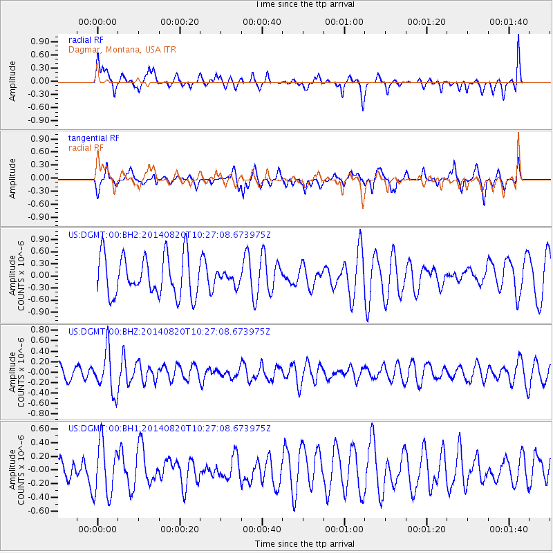
Signal To Noise
| Channel | StoN | STA | LTA |
| US:DGMT:00:BHZ:20140820T10:27:08.673975Z | 2.0576577 | 4.1577317E-7 | 2.0206139E-7 |
| US:DGMT:00:BH1:20140820T10:27:08.673975Z | 1.2770875 | 3.8203942E-7 | 2.9914898E-7 |
| US:DGMT:00:BH2:20140820T10:27:08.673975Z | 0.30198926 | 1.5131033E-7 | 5.010454E-7 |
| Arrivals |
| Ps | |
| PpPs | |
| PsPs/PpSs | |


