You are here: Home > Network List > IC - New China Digital Seismograph Network Stations List
> Station KMI Kunming, Yunnan Province, China > Earthquake Result Viewer
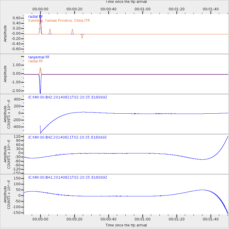
KMI Kunming, Yunnan Province, China - Earthquake Result Viewer
| Earthquake location: |
New Britain Region, P.N.G. |
| Earthquake latitude/longitude: |
-5.2/150.7 |
| Earthquake time(UTC): |
2014/08/21 (233) 02:11:32 GMT |
| Earthquake Depth: |
12 km |
| Earthquake Magnitude: |
5.8 MWP |
| Earthquake Catalog/Contributor: |
NEIC PDE/NEIC COMCAT |
|
| Network: |
IC New China Digital Seismograph Network |
| Station: |
KMI Kunming, Yunnan Province, China |
| Lat/Lon: |
25.12 N/102.74 E |
| Elevation: |
1975 m |
|
| Distance: |
55.5 deg |
| Az: |
305.25 deg |
| Baz: |
116.208 deg |
| Ray Param: |
0.06477121 |
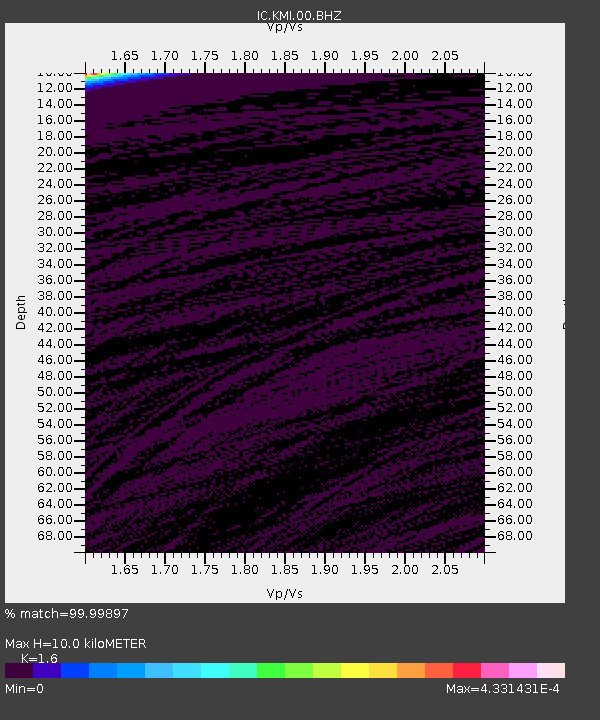
| Estimated Moho Depth: |
10.0 km |
| Estimated Crust Vp/Vs: |
1.60 |
| Assumed Crust Vp: |
6.247 km/s |
| Estimated Crust Vs: |
3.904 km/s |
| Estimated Crust Poisson's Ratio: |
0.18 |
|
| Radial Match: |
99.99897 % |
| Radial Bump: |
2 |
| Transverse Match: |
99.99885 % |
| Transverse Bump: |
2 |
| SOD ConfigId: |
769524 |
| Insert Time: |
2014-09-04 02:35:27.279 +0000 |
| GWidth: |
2.5 |
| Max Bumps: |
400 |
| Tol: |
0.001 |
|
Signal To Noise
| Channel | StoN | STA | LTA |
| IC:KMI:00:BHZ:20140821T02:20:35.818999Z | 0.9364161 | 1.3917821E-4 | 1.486286E-4 |
| IC:KMI:00:BH1:20140821T02:20:35.818999Z | 0.9363657 | 1.6765278E-4 | 1.7904624E-4 |
| IC:KMI:00:BH2:20140821T02:20:35.818999Z | 0.9365863 | 1.6795837E-4 | 1.7933037E-4 |
| Arrivals |
| Ps | 1.0 SECOND |
| PpPs | 3.9 SECOND |
| PsPs/PpSs | 5.0 SECOND |


