You are here: Home > Network List > AV - Alaska Volcano Observatory Stations List
> Station SPCR Ckakachatna River, Mount Spurr, Alaska > Earthquake Result Viewer
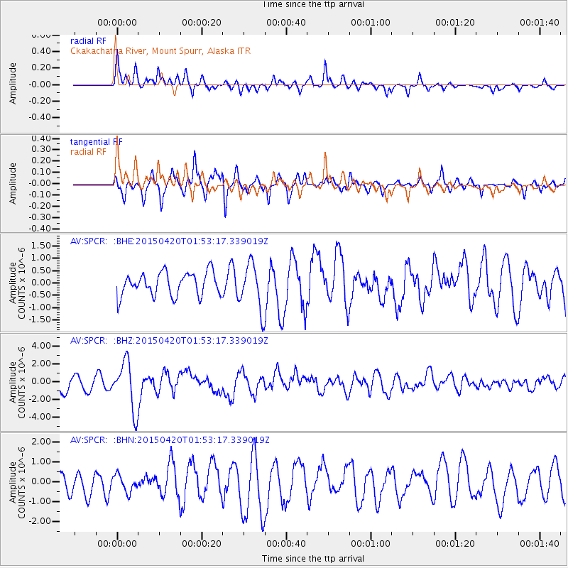
SPCR Ckakachatna River, Mount Spurr, Alaska - Earthquake Result Viewer
*The percent match for this event was below the threshold and hence no stack was calculated.
| Earthquake location: |
Taiwan Region |
| Earthquake latitude/longitude: |
24.1/122.3 |
| Earthquake time(UTC): |
2015/04/20 (110) 01:42:58 GMT |
| Earthquake Depth: |
29 km |
| Earthquake Magnitude: |
6.6 MWP, 6.6 MI |
| Earthquake Catalog/Contributor: |
NEIC PDE/NEIC COMCAT |
|
| Network: |
AV Alaska Volcano Observatory |
| Station: |
SPCR Ckakachatna River, Mount Spurr, Alaska |
| Lat/Lon: |
61.20 N/152.21 W |
| Elevation: |
984 m |
|
| Distance: |
67.0 deg |
| Az: |
31.628 deg |
| Baz: |
278.34 deg |
| Ray Param: |
$rayparam |
*The percent match for this event was below the threshold and hence was not used in the summary stack. |
|
| Radial Match: |
75.068405 % |
| Radial Bump: |
400 |
| Transverse Match: |
74.69835 % |
| Transverse Bump: |
371 |
| SOD ConfigId: |
7422571 |
| Insert Time: |
2019-04-18 06:23:08.489 +0000 |
| GWidth: |
2.5 |
| Max Bumps: |
400 |
| Tol: |
0.001 |
|
Signal To Noise
| Channel | StoN | STA | LTA |
| AV:SPCR: :BHZ:20150420T01:53:17.339019Z | 3.5326931 | 2.8426198E-6 | 8.0466083E-7 |
| AV:SPCR: :BHN:20150420T01:53:17.339019Z | 0.6345148 | 4.2852997E-7 | 6.7536644E-7 |
| AV:SPCR: :BHE:20150420T01:53:17.339019Z | 2.2035213 | 1.0116607E-6 | 4.5911096E-7 |
| Arrivals |
| Ps | |
| PpPs | |
| PsPs/PpSs | |


