You are here: Home > Network List > AV - Alaska Volcano Observatory Stations List
> Station MAPS Pakushin Southeast, Makushin Volcano, Alaska > Earthquake Result Viewer
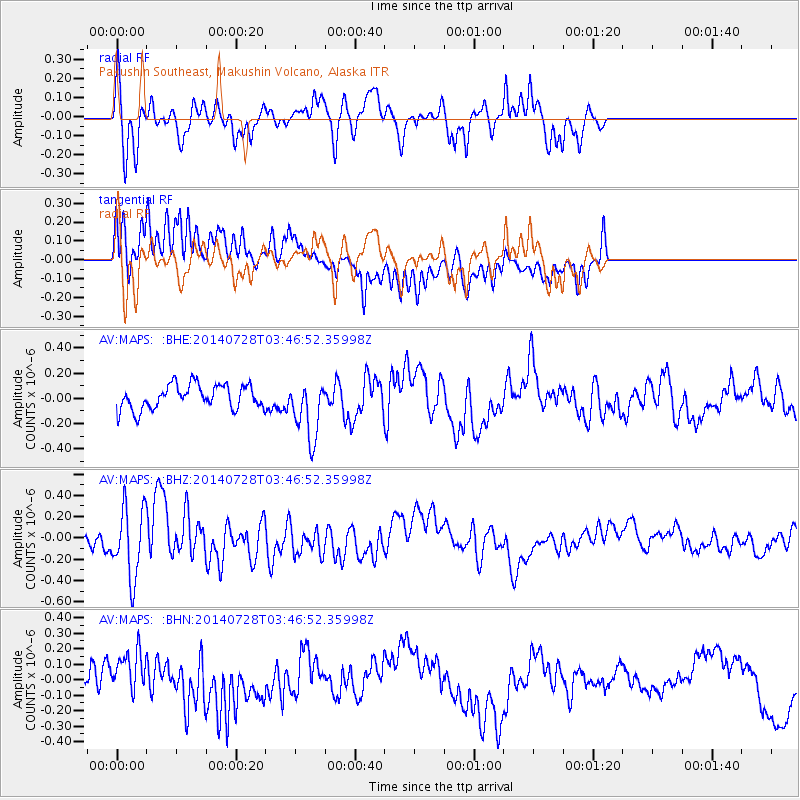
MAPS Pakushin Southeast, Makushin Volcano, Alaska - Earthquake Result Viewer
*The percent match for this event was below the threshold and hence no stack was calculated.
| Earthquake location: |
W. Caroline Islands, Micronesia |
| Earthquake latitude/longitude: |
7.5/136.8 |
| Earthquake time(UTC): |
2014/07/28 (209) 03:36:45 GMT |
| Earthquake Depth: |
4.2 km |
| Earthquake Magnitude: |
5.6 MWW, 5.5 MWC, 5.6 MWB |
| Earthquake Catalog/Contributor: |
NEIC PDE/NEIC COMCAT |
|
| Network: |
AV Alaska Volcano Observatory |
| Station: |
MAPS Pakushin Southeast, Makushin Volcano, Alaska |
| Lat/Lon: |
53.81 N/166.94 W |
| Elevation: |
333 m |
|
| Distance: |
64.5 deg |
| Az: |
33.139 deg |
| Baz: |
246.061 deg |
| Ray Param: |
$rayparam |
*The percent match for this event was below the threshold and hence was not used in the summary stack. |
|
| Radial Match: |
70.423615 % |
| Radial Bump: |
400 |
| Transverse Match: |
50.016186 % |
| Transverse Bump: |
400 |
| SOD ConfigId: |
769524 |
| Insert Time: |
2014-09-05 23:08:41.870 +0000 |
| GWidth: |
2.5 |
| Max Bumps: |
400 |
| Tol: |
0.001 |
|
Signal To Noise
| Channel | StoN | STA | LTA |
| AV:MAPS: :BHZ:20140728T03:46:52.35998Z | 3.1881988 | 3.250471E-7 | 1.0195321E-7 |
| AV:MAPS: :BHN:20140728T03:46:52.35998Z | 0.98660755 | 1.5864651E-7 | 1.6080001E-7 |
| AV:MAPS: :BHE:20140728T03:46:52.35998Z | 2.406328 | 2.3344688E-7 | 9.701374E-8 |
| Arrivals |
| Ps | |
| PpPs | |
| PsPs/PpSs | |


