You are here: Home > Network List > XD14 - Illuminating the architecture of the greater Mount St. Helens magmatic systems f Stations List
> Station ME04 "Mount St Helens, WA" > Earthquake Result Viewer
ME04 "Mount St Helens, WA" - Earthquake Result Viewer
| Earthquake location: |
Taiwan Region |
| Earthquake latitude/longitude: |
24.1/122.3 |
| Earthquake time(UTC): |
2015/04/20 (110) 01:42:58 GMT |
| Earthquake Depth: |
29 km |
| Earthquake Magnitude: |
6.6 MWP, 6.6 MI |
| Earthquake Catalog/Contributor: |
NEIC PDE/NEIC COMCAT |
|
| Network: |
XD Illuminating the architecture of the greater Mount St. Helens magmatic systems f |
| Station: |
ME04 "Mount St Helens, WA" |
| Lat/Lon: |
46.45 N/122.35 W |
| Elevation: |
730 m |
|
| Distance: |
88.6 deg |
| Az: |
38.696 deg |
| Baz: |
304.295 deg |
| Ray Param: |
0.042395875 |
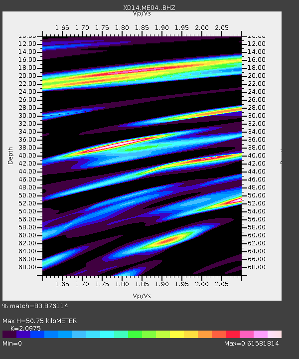
| Estimated Moho Depth: |
50.75 km |
| Estimated Crust Vp/Vs: |
2.10 |
| Assumed Crust Vp: |
6.566 km/s |
| Estimated Crust Vs: |
3.13 km/s |
| Estimated Crust Poisson's Ratio: |
0.35 |
|
| Radial Match: |
83.876114 % |
| Radial Bump: |
400 |
| Transverse Match: |
63.059143 % |
| Transverse Bump: |
400 |
| SOD ConfigId: |
7422571 |
| Insert Time: |
2019-04-18 06:28:04.341 +0000 |
| GWidth: |
2.5 |
| Max Bumps: |
400 |
| Tol: |
0.001 |
|

Signal To Noise
| Channel | StoN | STA | LTA |
| XD:ME04: :BHZ:20150420T01:55:17.144988Z | 10.154773 | 1.5794044E-6 | 1.555332E-7 |
| XD:ME04: :BHN:20150420T01:55:17.144988Z | 2.6230652 | 3.8139152E-7 | 1.4539917E-7 |
| XD:ME04: :BHE:20150420T01:55:17.144988Z | 4.051817 | 6.478001E-7 | 1.5987891E-7 |
| Arrivals |
| Ps | 8.6 SECOND |
| PpPs | 23 SECOND |
| PsPs/PpSs | 32 SECOND |


