You are here: Home > Network List > XD14 - Illuminating the architecture of the greater Mount St. Helens magmatic systems f Stations List
> Station MG06 "Mount St Helens, WA" > Earthquake Result Viewer
MG06 "Mount St Helens, WA" - Earthquake Result Viewer
| Earthquake location: |
Taiwan Region |
| Earthquake latitude/longitude: |
24.1/122.3 |
| Earthquake time(UTC): |
2015/04/20 (110) 01:42:58 GMT |
| Earthquake Depth: |
29 km |
| Earthquake Magnitude: |
6.6 MWP, 6.6 MI |
| Earthquake Catalog/Contributor: |
NEIC PDE/NEIC COMCAT |
|
| Network: |
XD Illuminating the architecture of the greater Mount St. Helens magmatic systems f |
| Station: |
MG06 "Mount St Helens, WA" |
| Lat/Lon: |
46.35 N/122.22 W |
| Elevation: |
1408 m |
|
| Distance: |
88.8 deg |
| Az: |
38.727 deg |
| Baz: |
304.393 deg |
| Ray Param: |
0.04229611 |
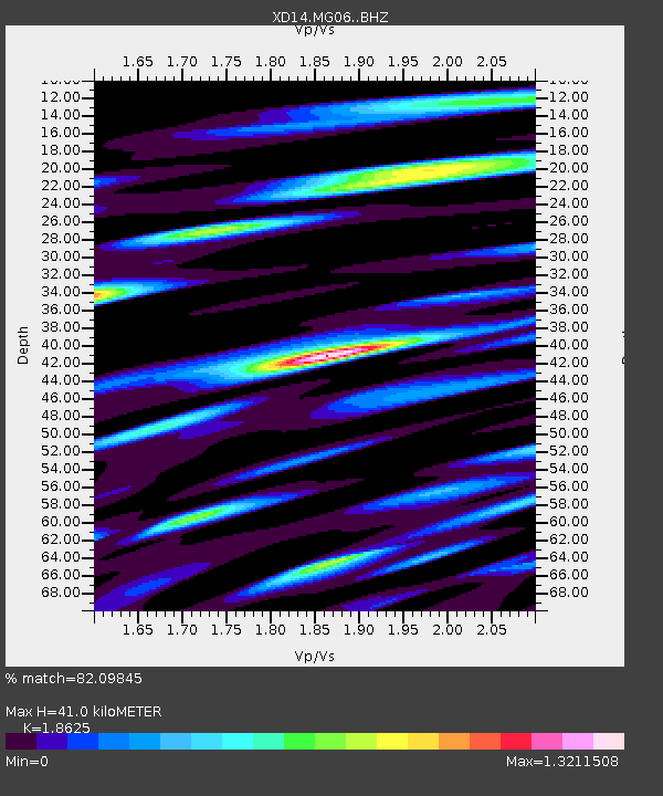
| Estimated Moho Depth: |
41.0 km |
| Estimated Crust Vp/Vs: |
1.86 |
| Assumed Crust Vp: |
6.566 km/s |
| Estimated Crust Vs: |
3.525 km/s |
| Estimated Crust Poisson's Ratio: |
0.30 |
|
| Radial Match: |
82.09845 % |
| Radial Bump: |
400 |
| Transverse Match: |
66.86714 % |
| Transverse Bump: |
400 |
| SOD ConfigId: |
7422571 |
| Insert Time: |
2019-04-18 06:28:11.201 +0000 |
| GWidth: |
2.5 |
| Max Bumps: |
400 |
| Tol: |
0.001 |
|

Signal To Noise
| Channel | StoN | STA | LTA |
| XD:MG06: :BHZ:20150420T01:55:17.769988Z | 12.447516 | 1.4873151E-6 | 1.194869E-7 |
| XD:MG06: :BHN:20150420T01:55:17.769988Z | 4.4156814 | 5.170835E-7 | 1.17101635E-7 |
| XD:MG06: :BHE:20150420T01:55:17.769988Z | 3.653014 | 5.197381E-7 | 1.4227652E-7 |
| Arrivals |
| Ps | 5.5 SECOND |
| PpPs | 17 SECOND |
| PsPs/PpSs | 23 SECOND |


