You are here: Home > Network List > YB13 - Continental Dynamics/Cent. Anatolian Tectonics:Surface to Mantle Dynamics During Stations List
> Station AT20 Kirkpinar,Kersehir,Turkey > Earthquake Result Viewer
AT20 Kirkpinar,Kersehir,Turkey - Earthquake Result Viewer
| Earthquake location: |
Taiwan Region |
| Earthquake latitude/longitude: |
24.1/122.3 |
| Earthquake time(UTC): |
2015/04/20 (110) 01:42:58 GMT |
| Earthquake Depth: |
29 km |
| Earthquake Magnitude: |
6.6 MWP, 6.6 MI |
| Earthquake Catalog/Contributor: |
NEIC PDE/NEIC COMCAT |
|
| Network: |
YB Continental Dynamics/Cent. Anatolian Tectonics:Surface to Mantle Dynamics During |
| Station: |
AT20 Kirkpinar,Kersehir,Turkey |
| Lat/Lon: |
39.36 N/34.16 E |
| Elevation: |
1235 m |
|
| Distance: |
73.8 deg |
| Az: |
306.202 deg |
| Baz: |
71.996 deg |
| Ray Param: |
0.052736335 |
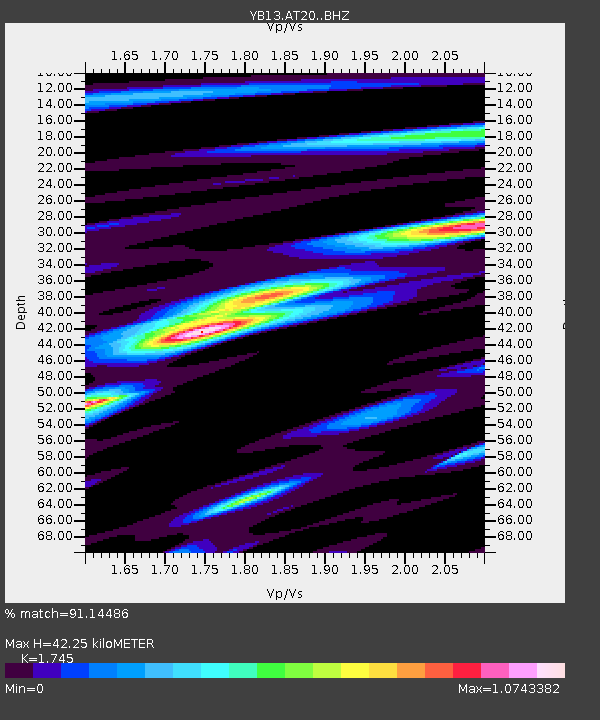
| Estimated Moho Depth: |
42.25 km |
| Estimated Crust Vp/Vs: |
1.75 |
| Assumed Crust Vp: |
6.35 km/s |
| Estimated Crust Vs: |
3.639 km/s |
| Estimated Crust Poisson's Ratio: |
0.26 |
|
| Radial Match: |
91.14486 % |
| Radial Bump: |
400 |
| Transverse Match: |
86.29106 % |
| Transverse Bump: |
400 |
| SOD ConfigId: |
7422571 |
| Insert Time: |
2019-04-18 06:29:16.831 +0000 |
| GWidth: |
2.5 |
| Max Bumps: |
400 |
| Tol: |
0.001 |
|

Signal To Noise
| Channel | StoN | STA | LTA |
| YB:AT20: :BHZ:20150420T01:53:59.220Z | 35.147484 | 2.4036285E-6 | 6.838693E-8 |
| YB:AT20: :BHN:20150420T01:53:59.220Z | 5.964013 | 3.681988E-7 | 6.1736756E-8 |
| YB:AT20: :BHE:20150420T01:53:59.220Z | 14.675518 | 9.3574494E-7 | 6.376231E-8 |
| Arrivals |
| Ps | 5.1 SECOND |
| PpPs | 18 SECOND |
| PsPs/PpSs | 23 SECOND |


