You are here: Home > Network List > YB13 - Continental Dynamics/Cent. Anatolian Tectonics:Surface to Mantle Dynamics During Stations List
> Station AT31 Inalli,Nevsehir,Turkey > Earthquake Result Viewer
AT31 Inalli,Nevsehir,Turkey - Earthquake Result Viewer
| Earthquake location: |
Taiwan Region |
| Earthquake latitude/longitude: |
24.1/122.3 |
| Earthquake time(UTC): |
2015/04/20 (110) 01:42:58 GMT |
| Earthquake Depth: |
29 km |
| Earthquake Magnitude: |
6.6 MWP, 6.6 MI |
| Earthquake Catalog/Contributor: |
NEIC PDE/NEIC COMCAT |
|
| Network: |
YB Continental Dynamics/Cent. Anatolian Tectonics:Surface to Mantle Dynamics During |
| Station: |
AT31 Inalli,Nevsehir,Turkey |
| Lat/Lon: |
38.57 N/34.51 E |
| Elevation: |
1303 m |
|
| Distance: |
73.8 deg |
| Az: |
305.331 deg |
| Baz: |
71.973 deg |
| Ray Param: |
0.05274704 |
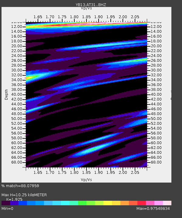
| Estimated Moho Depth: |
10.25 km |
| Estimated Crust Vp/Vs: |
1.92 |
| Assumed Crust Vp: |
6.35 km/s |
| Estimated Crust Vs: |
3.299 km/s |
| Estimated Crust Poisson's Ratio: |
0.32 |
|
| Radial Match: |
88.07959 % |
| Radial Bump: |
400 |
| Transverse Match: |
89.03879 % |
| Transverse Bump: |
400 |
| SOD ConfigId: |
7422571 |
| Insert Time: |
2019-04-18 06:29:21.334 +0000 |
| GWidth: |
2.5 |
| Max Bumps: |
400 |
| Tol: |
0.001 |
|

Signal To Noise
| Channel | StoN | STA | LTA |
| YB:AT31: :BHZ:20150420T01:53:59.139983Z | 47.25747 | 2.465668E-6 | 5.2175203E-8 |
| YB:AT31: :BHN:20150420T01:53:59.139983Z | 9.896692 | 6.752512E-7 | 6.822999E-8 |
| YB:AT31: :BHE:20150420T01:53:59.139983Z | 9.043166 | 7.5137024E-7 | 8.308707E-8 |
| Arrivals |
| Ps | 1.5 SECOND |
| PpPs | 4.6 SECOND |
| PsPs/PpSs | 6.1 SECOND |


