You are here: Home > Network List > TA - USArray Transportable Network (new EarthScope stations) Stations List
> Station R53A Hurricane, WV, USA > Earthquake Result Viewer
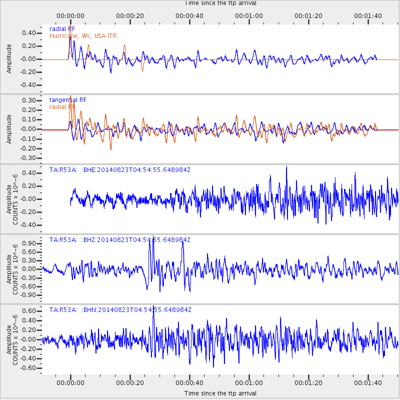
R53A Hurricane, WV, USA - Earthquake Result Viewer
*The percent match for this event was below the threshold and hence no stack was calculated.
| Earthquake location: |
Northern Chile |
| Earthquake latitude/longitude: |
-20.2/-69.1 |
| Earthquake time(UTC): |
2014/08/23 (235) 04:45:33 GMT |
| Earthquake Depth: |
98 km |
| Earthquake Magnitude: |
5.7 MB |
| Earthquake Catalog/Contributor: |
NEIC PDE/NEIC COMCAT |
|
| Network: |
TA USArray Transportable Network (new EarthScope stations) |
| Station: |
R53A Hurricane, WV, USA |
| Lat/Lon: |
38.33 N/81.95 W |
| Elevation: |
294 m |
|
| Distance: |
59.4 deg |
| Az: |
348.287 deg |
| Baz: |
165.966 deg |
| Ray Param: |
$rayparam |
*The percent match for this event was below the threshold and hence was not used in the summary stack. |
|
| Radial Match: |
73.85882 % |
| Radial Bump: |
400 |
| Transverse Match: |
56.932327 % |
| Transverse Bump: |
400 |
| SOD ConfigId: |
769524 |
| Insert Time: |
2014-09-06 05:19:34.777 +0000 |
| GWidth: |
2.5 |
| Max Bumps: |
400 |
| Tol: |
0.001 |
|
Signal To Noise
| Channel | StoN | STA | LTA |
| TA:R53A: :BHZ:20140823T04:54:55.648984Z | 2.2376797 | 1.8827504E-7 | 8.413851E-8 |
| TA:R53A: :BHN:20140823T04:54:55.648984Z | 1.5220577 | 1.007156E-7 | 6.617069E-8 |
| TA:R53A: :BHE:20140823T04:54:55.648984Z | 0.9773798 | 5.9223435E-8 | 6.059409E-8 |
| Arrivals |
| Ps | |
| PpPs | |
| PsPs/PpSs | |


