You are here: Home > Network List > YQ13 - Study of Extension and Magmatism in Malawi and Tanzania Stations List
> Station TOLA Matola,Tanzania > Earthquake Result Viewer
TOLA Matola,Tanzania - Earthquake Result Viewer
| Earthquake location: |
Taiwan Region |
| Earthquake latitude/longitude: |
24.1/122.3 |
| Earthquake time(UTC): |
2015/04/20 (110) 01:42:58 GMT |
| Earthquake Depth: |
29 km |
| Earthquake Magnitude: |
6.6 MWP, 6.6 MI |
| Earthquake Catalog/Contributor: |
NEIC PDE/NEIC COMCAT |
|
| Network: |
YQ Study of Extension and Magmatism in Malawi and Tanzania |
| Station: |
TOLA Matola,Tanzania |
| Lat/Lon: |
9.59 S/34.58 E |
| Elevation: |
2201 m |
|
| Distance: |
91.8 deg |
| Az: |
260.382 deg |
| Baz: |
65.98 deg |
| Ray Param: |
0.04154351 |
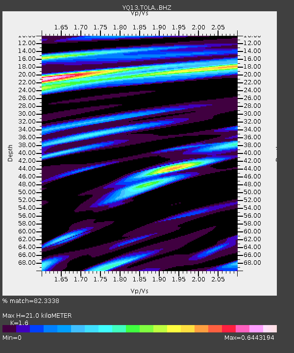
| Estimated Moho Depth: |
21.0 km |
| Estimated Crust Vp/Vs: |
1.60 |
| Assumed Crust Vp: |
6.576 km/s |
| Estimated Crust Vs: |
4.11 km/s |
| Estimated Crust Poisson's Ratio: |
0.18 |
|
| Radial Match: |
82.3338 % |
| Radial Bump: |
400 |
| Transverse Match: |
56.76606 % |
| Transverse Bump: |
400 |
| SOD ConfigId: |
7422571 |
| Insert Time: |
2019-04-18 06:30:10.613 +0000 |
| GWidth: |
2.5 |
| Max Bumps: |
400 |
| Tol: |
0.001 |
|

Signal To Noise
| Channel | StoN | STA | LTA |
| YQ:TOLA: :BHZ:20150420T01:55:32.245024Z | 7.745272 | 4.809862E-7 | 6.2100625E-8 |
| YQ:TOLA: :BHN:20150420T01:55:32.245024Z | 1.0585843 | 8.2409684E-8 | 7.784895E-8 |
| YQ:TOLA: :BHE:20150420T01:55:32.245024Z | 3.2106037 | 2.1639343E-7 | 6.7399604E-8 |
| Arrivals |
| Ps | 2.0 SECOND |
| PpPs | 8.1 SECOND |
| PsPs/PpSs | 10 SECOND |


