You are here: Home > Network List > TA - USArray Transportable Network (new EarthScope stations) Stations List
> Station T54A Tazewell, VA, USA > Earthquake Result Viewer
T54A Tazewell, VA, USA - Earthquake Result Viewer
| Earthquake location: |
Northern Chile |
| Earthquake latitude/longitude: |
-20.2/-69.1 |
| Earthquake time(UTC): |
2014/08/23 (235) 04:45:33 GMT |
| Earthquake Depth: |
98 km |
| Earthquake Magnitude: |
5.7 MB |
| Earthquake Catalog/Contributor: |
NEIC PDE/NEIC COMCAT |
|
| Network: |
TA USArray Transportable Network (new EarthScope stations) |
| Station: |
T54A Tazewell, VA, USA |
| Lat/Lon: |
37.06 N/81.58 W |
| Elevation: |
852 m |
|
| Distance: |
58.1 deg |
| Az: |
348.268 deg |
| Baz: |
166.184 deg |
| Ray Param: |
0.06276693 |
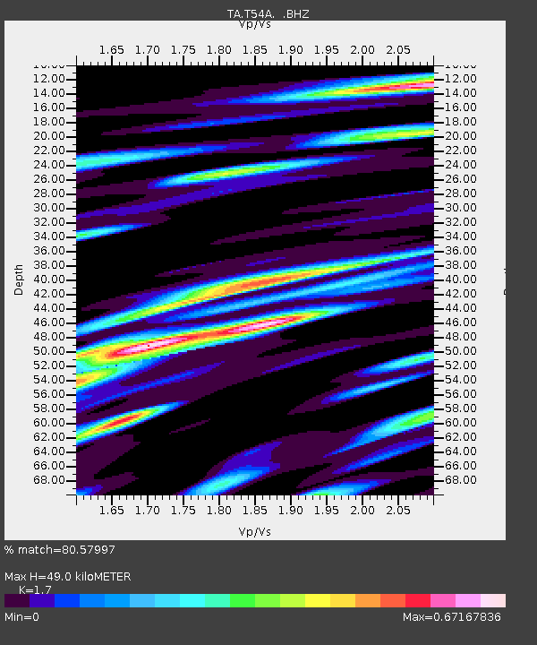
| Estimated Moho Depth: |
49.0 km |
| Estimated Crust Vp/Vs: |
1.70 |
| Assumed Crust Vp: |
6.159 km/s |
| Estimated Crust Vs: |
3.623 km/s |
| Estimated Crust Poisson's Ratio: |
0.24 |
|
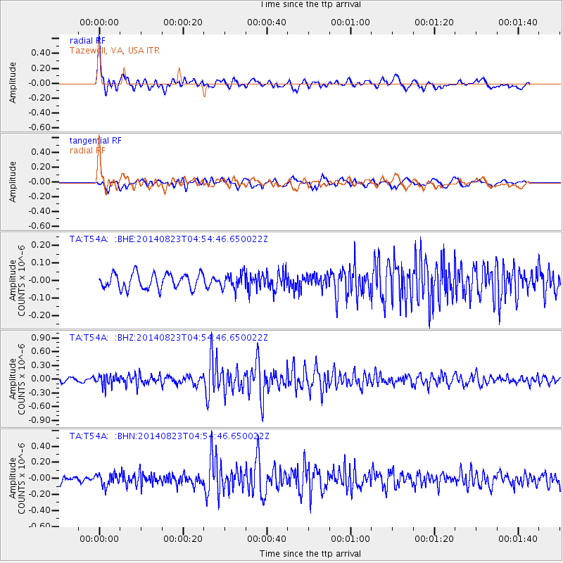
| Radial Match: |
80.57997 % |
| Radial Bump: |
400 |
| Transverse Match: |
70.67062 % |
| Transverse Bump: |
400 |
| SOD ConfigId: |
769524 |
| Insert Time: |
2014-09-06 05:20:20.726 +0000 |
| GWidth: |
2.5 |
| Max Bumps: |
400 |
| Tol: |
0.001 |
|
Signal To Noise
| Channel | StoN | STA | LTA |
| TA:T54A: :BHZ:20140823T04:54:46.650022Z | 1.9851918 | 1.1173782E-7 | 5.6285653E-8 |
| TA:T54A: :BHN:20140823T04:54:46.650022Z | 1.7819152 | 7.252635E-8 | 4.0701348E-8 |
| TA:T54A: :BHE:20140823T04:54:46.650022Z | 1.0143247 | 4.3917442E-8 | 4.3297224E-8 |
| Arrivals |
| Ps | 5.8 SECOND |
| PpPs | 21 SECOND |
| PsPs/PpSs | 26 SECOND |


