You are here: Home > Network List > TA - USArray Transportable Network (new EarthScope stations) Stations List
> Station W54A Cherokee Point, Campobello, SC, USA > Earthquake Result Viewer
W54A Cherokee Point, Campobello, SC, USA - Earthquake Result Viewer
| Earthquake location: |
Northern Chile |
| Earthquake latitude/longitude: |
-20.2/-69.1 |
| Earthquake time(UTC): |
2014/08/23 (235) 04:45:33 GMT |
| Earthquake Depth: |
98 km |
| Earthquake Magnitude: |
5.7 MB |
| Earthquake Catalog/Contributor: |
NEIC PDE/NEIC COMCAT |
|
| Network: |
TA USArray Transportable Network (new EarthScope stations) |
| Station: |
W54A Cherokee Point, Campobello, SC, USA |
| Lat/Lon: |
35.09 N/82.19 W |
| Elevation: |
272 m |
|
| Distance: |
56.3 deg |
| Az: |
347.119 deg |
| Baz: |
165.205 deg |
| Ray Param: |
0.06391825 |
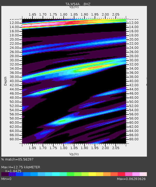
| Estimated Moho Depth: |
12.75 km |
| Estimated Crust Vp/Vs: |
1.64 |
| Assumed Crust Vp: |
6.35 km/s |
| Estimated Crust Vs: |
3.866 km/s |
| Estimated Crust Poisson's Ratio: |
0.21 |
|
| Radial Match: |
85.56297 % |
| Radial Bump: |
332 |
| Transverse Match: |
65.92288 % |
| Transverse Bump: |
400 |
| SOD ConfigId: |
769524 |
| Insert Time: |
2014-09-06 05:21:25.267 +0000 |
| GWidth: |
2.5 |
| Max Bumps: |
400 |
| Tol: |
0.001 |
|
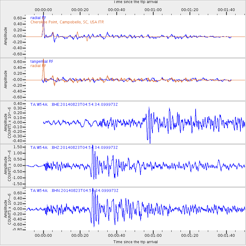
Signal To Noise
| Channel | StoN | STA | LTA |
| TA:W54A: :BHZ:20140823T04:54:34.099973Z | 2.4121454 | 1.5779943E-7 | 6.54187E-8 |
| TA:W54A: :BHN:20140823T04:54:34.099973Z | 2.559691 | 7.8140545E-8 | 3.052734E-8 |
| TA:W54A: :BHE:20140823T04:54:34.099973Z | 1.4224224 | 4.772628E-8 | 3.355282E-8 |
| Arrivals |
| Ps | 1.4 SECOND |
| PpPs | 5.0 SECOND |
| PsPs/PpSs | 6.4 SECOND |


