You are here: Home > Network List > TA - USArray Transportable Network (new EarthScope stations) Stations List
> Station W56A Indian Trail, NC, USA > Earthquake Result Viewer
W56A Indian Trail, NC, USA - Earthquake Result Viewer
| Earthquake location: |
Northern Chile |
| Earthquake latitude/longitude: |
-20.2/-69.1 |
| Earthquake time(UTC): |
2014/08/23 (235) 04:45:33 GMT |
| Earthquake Depth: |
98 km |
| Earthquake Magnitude: |
5.7 MB |
| Earthquake Catalog/Contributor: |
NEIC PDE/NEIC COMCAT |
|
| Network: |
TA USArray Transportable Network (new EarthScope stations) |
| Station: |
W56A Indian Trail, NC, USA |
| Lat/Lon: |
35.13 N/80.58 W |
| Elevation: |
177 m |
|
| Distance: |
56.1 deg |
| Az: |
348.669 deg |
| Baz: |
166.985 deg |
| Ray Param: |
0.06409308 |
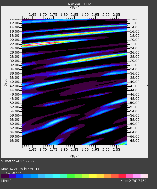
| Estimated Moho Depth: |
21.75 km |
| Estimated Crust Vp/Vs: |
1.68 |
| Assumed Crust Vp: |
6.419 km/s |
| Estimated Crust Vs: |
3.827 km/s |
| Estimated Crust Poisson's Ratio: |
0.22 |
|
| Radial Match: |
82.52756 % |
| Radial Bump: |
400 |
| Transverse Match: |
64.07383 % |
| Transverse Bump: |
400 |
| SOD ConfigId: |
769524 |
| Insert Time: |
2014-09-06 05:21:28.383 +0000 |
| GWidth: |
2.5 |
| Max Bumps: |
400 |
| Tol: |
0.001 |
|

Signal To Noise
| Channel | StoN | STA | LTA |
| TA:W56A: :BHZ:20140823T04:54:32.20001Z | 4.472347 | 2.3736735E-7 | 5.3074455E-8 |
| TA:W56A: :BHN:20140823T04:54:32.20001Z | 2.2244854 | 1.0246254E-7 | 4.606123E-8 |
| TA:W56A: :BHE:20140823T04:54:32.20001Z | 1.6587043 | 7.3128376E-8 | 4.4087653E-8 |
| Arrivals |
| Ps | 2.4 SECOND |
| PpPs | 8.6 SECOND |
| PsPs/PpSs | 11 SECOND |


