You are here: Home > Network List > TA - USArray Transportable Network (new EarthScope stations) Stations List
> Station W60A Pink Hill, NC, USA > Earthquake Result Viewer
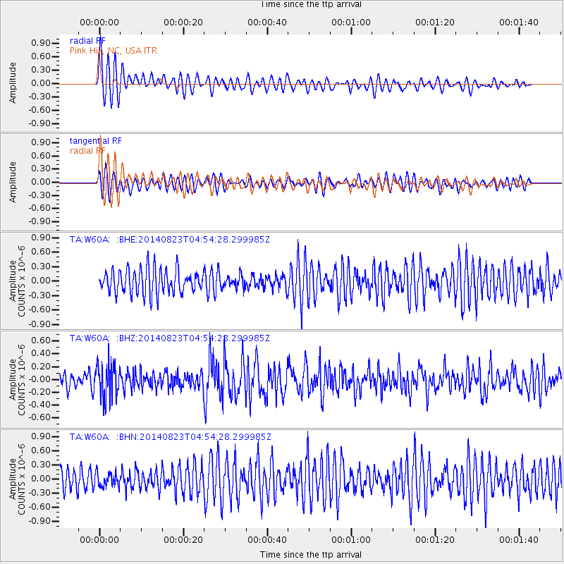
W60A Pink Hill, NC, USA - Earthquake Result Viewer
*The percent match for this event was below the threshold and hence no stack was calculated.
| Earthquake location: |
Northern Chile |
| Earthquake latitude/longitude: |
-20.2/-69.1 |
| Earthquake time(UTC): |
2014/08/23 (235) 04:45:33 GMT |
| Earthquake Depth: |
98 km |
| Earthquake Magnitude: |
5.7 MB |
| Earthquake Catalog/Contributor: |
NEIC PDE/NEIC COMCAT |
|
| Network: |
TA USArray Transportable Network (new EarthScope stations) |
| Station: |
W60A Pink Hill, NC, USA |
| Lat/Lon: |
35.05 N/77.71 W |
| Elevation: |
30 m |
|
| Distance: |
55.5 deg |
| Az: |
351.438 deg |
| Baz: |
170.185 deg |
| Ray Param: |
$rayparam |
*The percent match for this event was below the threshold and hence was not used in the summary stack. |
|
| Radial Match: |
78.96876 % |
| Radial Bump: |
400 |
| Transverse Match: |
49.267826 % |
| Transverse Bump: |
400 |
| SOD ConfigId: |
769524 |
| Insert Time: |
2014-09-06 05:21:37.271 +0000 |
| GWidth: |
2.5 |
| Max Bumps: |
400 |
| Tol: |
0.001 |
|
Signal To Noise
| Channel | StoN | STA | LTA |
| TA:W60A: :BHZ:20140823T04:54:28.299985Z | 2.8135533 | 2.7057996E-7 | 9.617019E-8 |
| TA:W60A: :BHN:20140823T04:54:28.299985Z | 0.5945705 | 1.4409044E-7 | 2.4234373E-7 |
| TA:W60A: :BHE:20140823T04:54:28.299985Z | 0.5120884 | 1.2515396E-7 | 2.4439913E-7 |
| Arrivals |
| Ps | |
| PpPs | |
| PsPs/PpSs | |


