You are here: Home > Network List > TA - USArray Transportable Network (new EarthScope stations) Stations List
> Station Y57A Sumter, SC, USA > Earthquake Result Viewer
Y57A Sumter, SC, USA - Earthquake Result Viewer

| Earthquake location: |
Northern Chile |
| Earthquake latitude/longitude: |
-20.2/-69.1 |
| Earthquake time(UTC): |
2014/08/23 (235) 04:45:33 GMT |
| Earthquake Depth: |
98 km |
| Earthquake Magnitude: |
5.7 MB |
| Earthquake Catalog/Contributor: |
NEIC PDE/NEIC COMCAT |
|
| Network: |
TA USArray Transportable Network (new EarthScope stations) |
| Station: |
Y57A Sumter, SC, USA |
| Lat/Lon: |
34.02 N/80.39 W |
| Elevation: |
56 m |
|
| Distance: |
54.9 deg |
| Az: |
348.551 deg |
| Baz: |
167.027 deg |
| Ray Param: |
0.064819485 |
| Estimated Moho Depth: |
21.5 km |
| Estimated Crust Vp/Vs: |
1.66 |
| Assumed Crust Vp: |
6.419 km/s |
| Estimated Crust Vs: |
3.867 km/s |
| Estimated Crust Poisson's Ratio: |
0.22 |
|
| Radial Match: |
93.49485 % |
| Radial Bump: |
400 |
| Transverse Match: |
75.45596 % |
| Transverse Bump: |
400 |
| SOD ConfigId: |
769524 |
| Insert Time: |
2014-09-06 05:22:00.674 +0000 |
| GWidth: |
2.5 |
| Max Bumps: |
400 |
| Tol: |
0.001 |
|
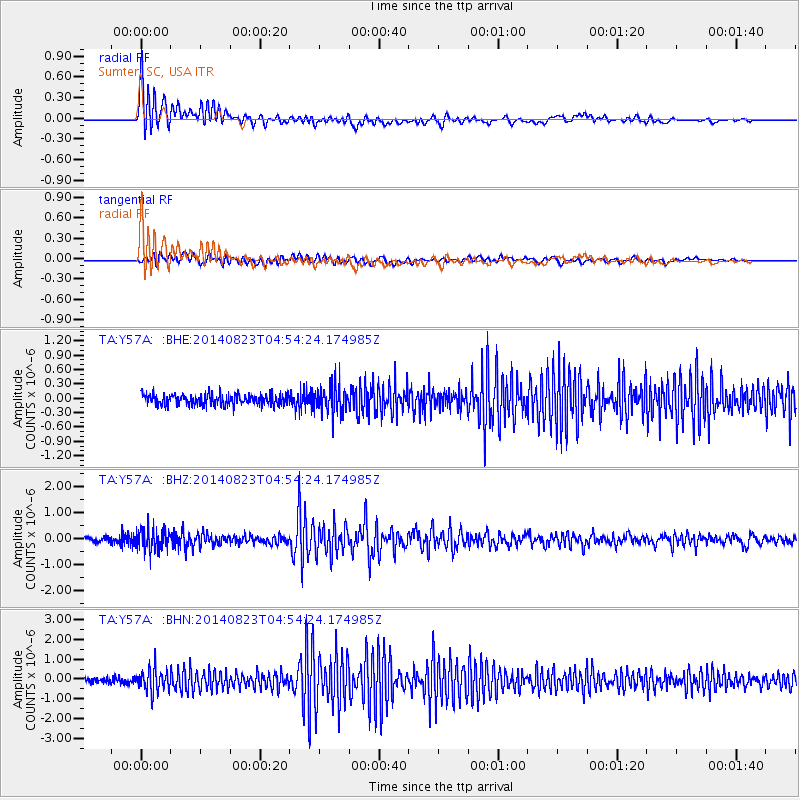
Signal To Noise
| Channel | StoN | STA | LTA |
| TA:Y57A: :BHZ:20140823T04:54:24.174985Z | 5.6856313 | 4.1667195E-7 | 7.328508E-8 |
| TA:Y57A: :BHN:20140823T04:54:24.174985Z | 5.092946 | 5.6527966E-7 | 1.10992666E-7 |
| TA:Y57A: :BHE:20140823T04:54:24.174985Z | 2.5159512 | 2.7793536E-7 | 1.10469294E-7 |
| Arrivals |
| Ps | 2.3 SECOND |
| PpPs | 8.4 SECOND |
| PsPs/PpSs | 11 SECOND |


