You are here: Home > Network List > AV - Alaska Volcano Observatory Stations List
> Station MNAT Nateekin Bay, Makushin Volcano, Alaska > Earthquake Result Viewer
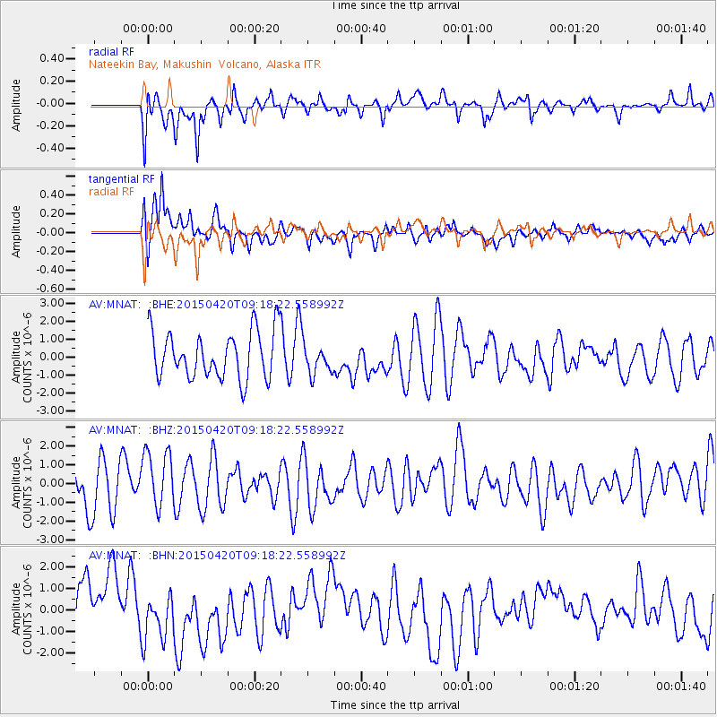
MNAT Nateekin Bay, Makushin Volcano, Alaska - Earthquake Result Viewer
*The percent match for this event was below the threshold and hence no stack was calculated.
| Earthquake location: |
Southern Sumatra, Indonesia |
| Earthquake latitude/longitude: |
-5.7/102.5 |
| Earthquake time(UTC): |
2015/04/20 (110) 09:05:31 GMT |
| Earthquake Depth: |
10 km |
| Earthquake Magnitude: |
6.0 MWP |
| Earthquake Catalog/Contributor: |
NEIC PDE/NEIC COMCAT |
|
| Network: |
AV Alaska Volcano Observatory |
| Station: |
MNAT Nateekin Bay, Makushin Volcano, Alaska |
| Lat/Lon: |
53.88 N/166.69 W |
| Elevation: |
390 m |
|
| Distance: |
95.1 deg |
| Az: |
36.462 deg |
| Baz: |
267.284 deg |
| Ray Param: |
$rayparam |
*The percent match for this event was below the threshold and hence was not used in the summary stack. |
|
| Radial Match: |
65.352936 % |
| Radial Bump: |
400 |
| Transverse Match: |
60.408028 % |
| Transverse Bump: |
400 |
| SOD ConfigId: |
7422571 |
| Insert Time: |
2019-04-18 06:30:54.709 +0000 |
| GWidth: |
2.5 |
| Max Bumps: |
400 |
| Tol: |
0.001 |
|
Signal To Noise
| Channel | StoN | STA | LTA |
| AV:MNAT: :BHZ:20150420T09:18:22.558992Z | 1.4593287 | 1.5725961E-6 | 1.0776162E-6 |
| AV:MNAT: :BHN:20150420T09:18:22.558992Z | 0.83912116 | 1.1539912E-6 | 1.375238E-6 |
| AV:MNAT: :BHE:20150420T09:18:22.558992Z | 0.6264276 | 8.192494E-7 | 1.3078118E-6 |
| Arrivals |
| Ps | |
| PpPs | |
| PsPs/PpSs | |


