You are here: Home > Network List > WY - Yellowstone Wyoming Seismic Network Stations List
> Station YHH Holmes Hill, YNP, WY, USA > Earthquake Result Viewer
YHH Holmes Hill, YNP, WY, USA - Earthquake Result Viewer
| Earthquake location: |
Northern Chile |
| Earthquake latitude/longitude: |
-20.2/-69.1 |
| Earthquake time(UTC): |
2014/08/23 (235) 04:45:33 GMT |
| Earthquake Depth: |
98 km |
| Earthquake Magnitude: |
5.7 MB |
| Earthquake Catalog/Contributor: |
NEIC PDE/NEIC COMCAT |
|
| Network: |
WY Yellowstone Wyoming Seismic Network |
| Station: |
YHH Holmes Hill, YNP, WY, USA |
| Lat/Lon: |
44.79 N/110.85 W |
| Elevation: |
2717 m |
|
| Distance: |
75.0 deg |
| Az: |
330.61 deg |
| Baz: |
139.651 deg |
| Ray Param: |
0.051722635 |
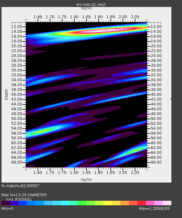
| Estimated Moho Depth: |
13.25 km |
| Estimated Crust Vp/Vs: |
1.93 |
| Assumed Crust Vp: |
6.35 km/s |
| Estimated Crust Vs: |
3.29 km/s |
| Estimated Crust Poisson's Ratio: |
0.32 |
|
| Radial Match: |
82.88597 % |
| Radial Bump: |
400 |
| Transverse Match: |
77.07219 % |
| Transverse Bump: |
400 |
| SOD ConfigId: |
769524 |
| Insert Time: |
2014-09-06 05:26:58.743 +0000 |
| GWidth: |
2.5 |
| Max Bumps: |
400 |
| Tol: |
0.001 |
|

Signal To Noise
| Channel | StoN | STA | LTA |
| WY:YHH:01:HHZ:20140823T04:56:33.83801Z | 3.5340934 | 9.554687E-9 | 2.703575E-9 |
| WY:YHH:01:HHN:20140823T04:56:33.83801Z | 2.5693502 | 2.8087443E-9 | 1.093173E-9 |
| WY:YHH:01:HHE:20140823T04:56:33.83801Z | 2.1655986 | 2.857471E-9 | 1.3194832E-9 |
| Arrivals |
| Ps | 2.0 SECOND |
| PpPs | 5.9 SECOND |
| PsPs/PpSs | 7.9 SECOND |


