You are here: Home > Network List > PE - Penn State Network Stations List
> Station PAGS PA Geological Survey > Earthquake Result Viewer
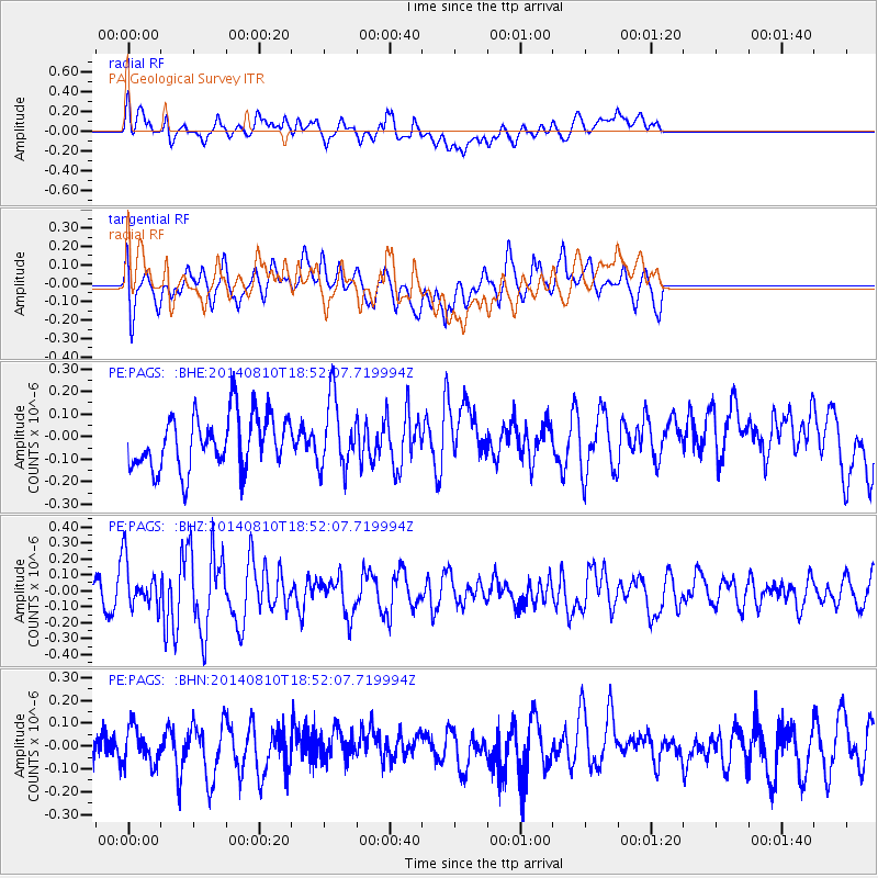
PAGS PA Geological Survey - Earthquake Result Viewer
*The percent match for this event was below the threshold and hence no stack was calculated.
| Earthquake location: |
Gulf Of California |
| Earthquake latitude/longitude: |
27.6/-111.6 |
| Earthquake time(UTC): |
2014/08/10 (222) 18:46:17 GMT |
| Earthquake Depth: |
10 km |
| Earthquake Magnitude: |
5.5 MWW, 5.4 MWB, 5.5 MWC |
| Earthquake Catalog/Contributor: |
NEIC PDE/NEIC COMCAT |
|
| Network: |
PE Penn State Network |
| Station: |
PAGS PA Geological Survey |
| Lat/Lon: |
40.23 N/76.72 W |
| Elevation: |
120 m |
|
| Distance: |
31.3 deg |
| Az: |
57.324 deg |
| Baz: |
257.249 deg |
| Ray Param: |
$rayparam |
*The percent match for this event was below the threshold and hence was not used in the summary stack. |
|
| Radial Match: |
45.019066 % |
| Radial Bump: |
400 |
| Transverse Match: |
55.052364 % |
| Transverse Bump: |
400 |
| SOD ConfigId: |
769524 |
| Insert Time: |
2014-09-06 17:53:38.118 +0000 |
| GWidth: |
2.5 |
| Max Bumps: |
400 |
| Tol: |
0.001 |
|
Signal To Noise
| Channel | StoN | STA | LTA |
| PE:PAGS: :BHZ:20140810T18:52:07.719994Z | 1.43355 | 1.5022712E-7 | 1.0479378E-7 |
| PE:PAGS: :BHN:20140810T18:52:07.719994Z | 0.7689879 | 7.886858E-8 | 1.0256153E-7 |
| PE:PAGS: :BHE:20140810T18:52:07.719994Z | 1.2988055 | 1.5397809E-7 | 1.1855363E-7 |
| Arrivals |
| Ps | |
| PpPs | |
| PsPs/PpSs | |


