You are here: Home > Network List > TA - USArray Transportable Network (new EarthScope stations) Stations List
> Station P59A Jarrettsville, MD, USA > Earthquake Result Viewer
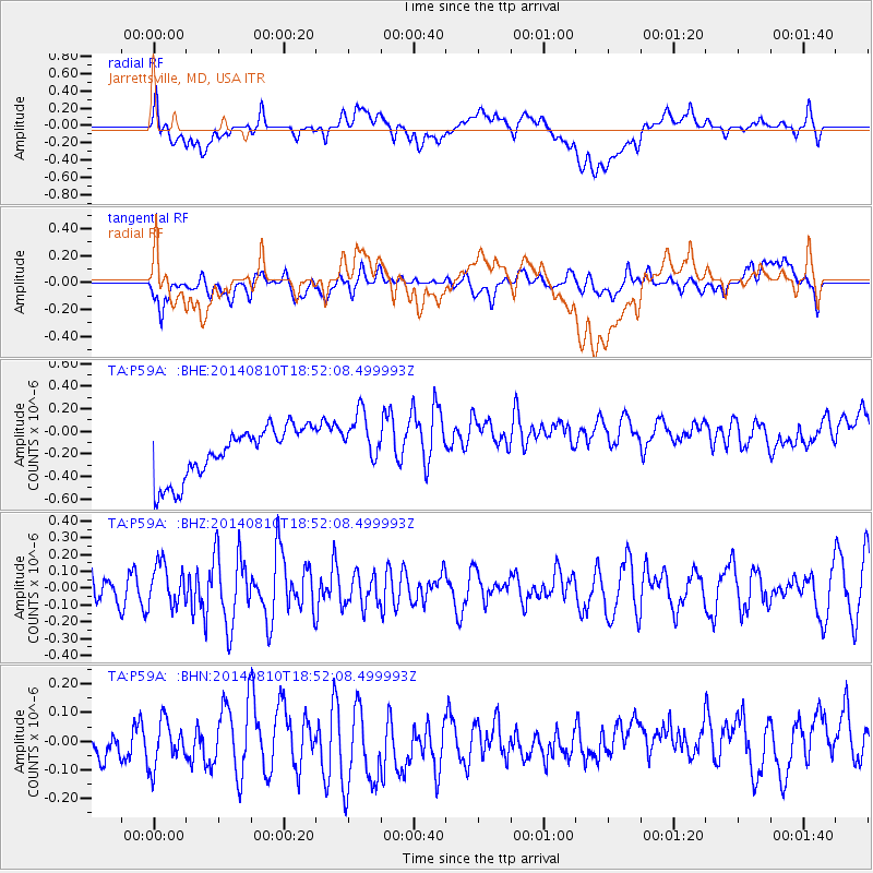
P59A Jarrettsville, MD, USA - Earthquake Result Viewer
*The percent match for this event was below the threshold and hence no stack was calculated.
| Earthquake location: |
Gulf Of California |
| Earthquake latitude/longitude: |
27.6/-111.6 |
| Earthquake time(UTC): |
2014/08/10 (222) 18:46:17 GMT |
| Earthquake Depth: |
10 km |
| Earthquake Magnitude: |
5.5 MWW, 5.4 MWB, 5.5 MWC |
| Earthquake Catalog/Contributor: |
NEIC PDE/NEIC COMCAT |
|
| Network: |
TA USArray Transportable Network (new EarthScope stations) |
| Station: |
P59A Jarrettsville, MD, USA |
| Lat/Lon: |
39.61 N/76.43 W |
| Elevation: |
157 m |
|
| Distance: |
31.4 deg |
| Az: |
58.572 deg |
| Baz: |
258.499 deg |
| Ray Param: |
$rayparam |
*The percent match for this event was below the threshold and hence was not used in the summary stack. |
|
| Radial Match: |
37.399525 % |
| Radial Bump: |
400 |
| Transverse Match: |
44.74438 % |
| Transverse Bump: |
400 |
| SOD ConfigId: |
769524 |
| Insert Time: |
2014-09-06 17:57:12.777 +0000 |
| GWidth: |
2.5 |
| Max Bumps: |
400 |
| Tol: |
0.001 |
|
Signal To Noise
| Channel | StoN | STA | LTA |
| TA:P59A: :BHZ:20140810T18:52:08.499993Z | 1.218823 | 1.2297973E-7 | 1.0090041E-7 |
| TA:P59A: :BHN:20140810T18:52:08.499993Z | 0.9183521 | 9.575466E-8 | 1.0426791E-7 |
| TA:P59A: :BHE:20140810T18:52:08.499993Z | 1.0946904 | 2.46964E-7 | 2.2560167E-7 |
| Arrivals |
| Ps | |
| PpPs | |
| PsPs/PpSs | |


